


45
Units of Measure
The GlobalMap 12 can show its data in many dif-
ferent formats. For example, distance can be dis-
played in statute miles (MI), nautical miles (NM),
or kilometers (KM).
The following can be changed on the Units of Mea-
sure menu: (Defaults shown in bold)
Distance .................. miles, nautical miles, kilometers
Speed...................... miles per hour, knots, kilometers per hour
Bearing.................... magnetic, true
Altitude .................... feet, meters
Clock ....................... 12-hour (a.m.-p.m.), 24 hour
Position Format ....... degrees, minutes, and thousands of a minute
degrees, minutes, seconds
UTM
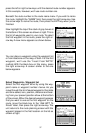
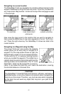
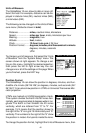
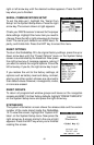
To change a unit of measure, first select the “Units
of Measure” from the “System Setup” menu. The
screen shown at right appears. To change a set-
ting on this menu, highlight the desired selection,
then press the left or right arrow key. You can
change one or all of the settings on this page. When
you’re finished, press the EXIT key.
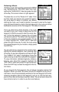
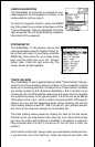
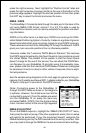
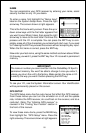
Position Format
The GlobalMap 12 can show the position in degrees, minutes, and hun-
dredths of a minute (36° 26.106') or degrees, minutes, and seconds (36°
26' 06.3". It can also show position in UTM’s or Universal Transverse Mer-
cator projection.
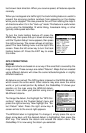
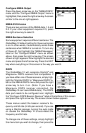
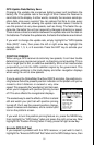
UTM’s are marked on USGS topographic charts.
This system divides the Earth into 60 zones hori-
zontally, each approximately 6 degrees wide in lon-
gitude. The Earth is then divided into 20 zones
vertically, which are lettered from “C” to “X”. For
example, 15 S means that the position shown to
the right of the “S” is in grid 15 horizontally and “S”
vertically. The numbers to the right of the “S” show
the position in meters from points inside the zone.
To change the position format, highlight the Units of Measure menu, then