


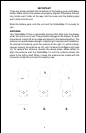

12
Navigation Screens
There are two navigation screens. Nav screen number one shows a graphi-
cal view of your trip, the other screen shows all navigation details in large
digital numbers.
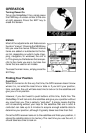
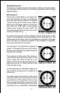
Nav Screen #1
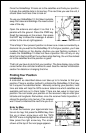
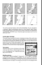
This screen is dominated by a compass rose.
Your track (direction of travel) is indicated by
an arrow pointing down toward the compass
rose at the top center of the screen. Track is
also shown in the upper right corner of the dis-
play under the “TRK” label. In the example
screen shown at right, the track is 355°. The
line extending behind the arrow in the center
shows your track history.
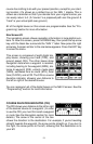
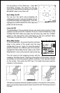
Your speed over ground or Ground Speed is shown at the bottom of this
screen. In this example, the ground speed is 21.3 miles per hour. The
screen looks like this when you’re not navigating to a waypoint. (See page
39 for information on waypoint navigation.) If you navigate to a waypoint,
the screen looks like the one below.
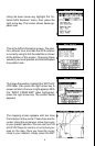
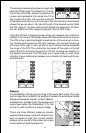
The bearing to the destination waypoint is
shown in the upper left corner of the screen.
Bearing is also shown by the large arrow point-
ing up to the compass.
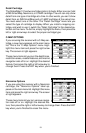
The numbers on either side of the center ar-
row show the cross track error range. In other
words, (using the screen at right as an ex-
ample) if the arrow crosses the dark band on
either side, you are .10 miles to the left or right
of the desired course.
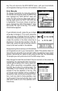
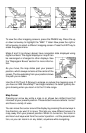
A circle depicting your destination appears on
the screen as you approach the waypoint, as
shown here.
The digital boxes at the bottom of the screen
show (from left to right) your distance to go to
the destination (DIS), estimated time en route
(ETE), ground speed (GS), and course (CRS).
Course (CRS) is the bearing from your start-
ing location to your destination. (Remember,