


20
Fill With Gray
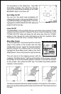
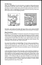
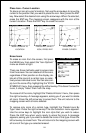
When the GlobalMap 12 is first turned on, all water is filled with gray to
distinguish it from land, which is clear. (See below) To make the land fill
with gray and water remain clear, press the down arrow key until the “Fill
With Gray” menu is highlighted, then press the left arrow key. Press the
EXIT key to return to the mapping screen.
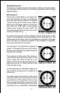
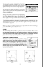
FILL WITH GRAY - LAND
FILL WITH GRAY - WATER
Normally, you'll want to fill water with gray when you're using the GPS
receiver on land and fill land with gray when you're using it on the water.
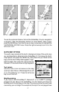
Map Orientation
By default, the GlobalMap 12 shows the map with north always at the top
of the screen. This is the way most maps and charts are printed on paper.
This is fine if you’re always travelling due north. What you see to your left
corresponds to the left side of the map, to your right is shown on the right
side of the map, and so on. However, if you travel any other direction, the
map doesn’t line up with your view of the world.
To correct this problem, the GlobalMap 12 has a track-up mode that ro-
tates the map as you turn. Thus, what you see on the left side of the
screen should always be to your left, and so on. It also has a course-up
mode that keeps the map at the same orientation as your initial bearing to
the waypoint.
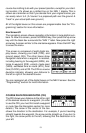
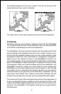
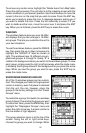
In the example at the top of the next page, we're travelling northeast to-
wards waypoint number 2. In the north-up view, the present position indi-
cator appears to move towards the upper right corner of the screen. In the
track-up view, the present position moves straight towards the top of the
display. A "N" shows to help you see which direction is north when the
track-up mode is on. Remember, in the track-up mode, the screen rotates
as you change direction. It always keeps your direction of travel (track)
heading towards the top of the screen.