


14
Mapping
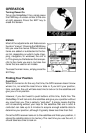
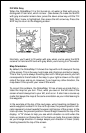
The GlobalMap 12 has a ground map of the world built inside. This map
has the majority of its detail in far southern Canada, the continental United
States and Hawaiian islands, northern Mexico,
the Bahamas, and Bermuda. The background
map shows when the GlobalMap 12 is first
turned on, with or without a map cartridge.
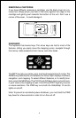
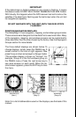
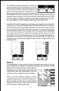
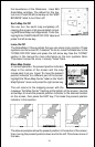
There are three different mapping screens
available. Map screen number 3 shows by de-
fault, as shown at right. Your current position
displays at the center of the screen by a cross
surrounded by a flashing diamond.
The smaller arrows pointing down on each side
show the CDI’s range. The default is 1/10 mile.
The small vertical bar shows the distance off
course and represents the course line. If the
bar moves to the right, then you are to the left
of the desired course line, and vice-versa. The CDI indicator shown above
shows that we are about .02 miles to the left of the desired course. (With
the CDI range of .10 miles, each vertical dotted line represents .02 mile.)
You can adjust the CDI’s range through the “Alarms/CDI” menu.
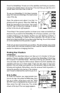
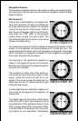
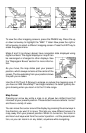
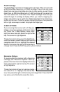
Using the CDI with a mapping screen helps you visualize your position in
relation to the course. The screen below left shows that we are on course.
The CDI arrow is pointing straight ahead and no off-course bar is show-
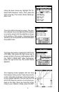
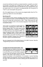
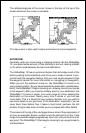
ing. Looking at the screen on the right, however, you can see that we are
off course to the right. In fact, we are so far off course that we exceeded
the range of the CDI. The vertical bar has gone off the scale on the left
side of the CDI. A small arrow points to the left, showing the direction to
the desired course line. The CDI gives you a quick, easy to read visual
indicator of your relationship between your direction of travel and the de-
sired direction.