


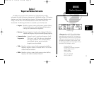

• Intersections - Identifier, country, position (lat/lon), nearest VOR.
• FSS - Identifier, reference VOR, frequency and usage.
• Minimum Safe Altitude - Minimum altitude you can fly and remain
(MSA) above obstructions in the region. Enroute
Safe Altitude (ESA) is the minimum safe
altitude along a route or direct-to.
• Controlled and - Type, name, controlling agency, boundaries, floor and
Special Use ceiling altitudes and controlling airport identifier.
Airspace
Updates for the GPS 150 database may be purchased from Jeppesen on a one-time
basis or by subscription. A packet supplied with your GPS 150 details the subscription
cycles and prices.
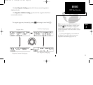
The GPS 150 database information is accessed using the
W
key. The GPS 150
contains four pages under the
W
key. These pages are:
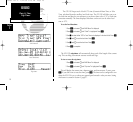
The Waypoint Menu page lets the user select the type of waypoint they would
like to see information regarding. After selecting the waypoint type, the user may
enter the identifier, location, or facility name to access the data contained on the
NavData card.
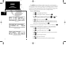
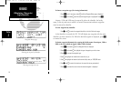
The Proximity Waypoint page lists all of the proximity waypoints the user has
entered. Proximity waypoints notify the pilot if the aircraft comes within a user entered
range of the waypoint’s position.
24
REFERENCE
Database Information
Section
2
150man rev E 7/24/98 3:10 PM Page 24