


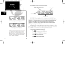
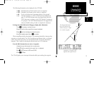
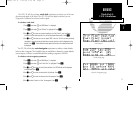


The GPS 150 will also perform winds aloft calculations to inform you of the true
direction and speed of the wind. The GPS 150 will also display whether you are
flying with a headwind or tailwind, and its speed.
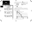
To calculate winds aloft:
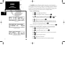
1. Press
N
and rotate
O
until NAV Menu 1 is displayed.
2. Press
C
and rotate
O
until ‘Winds?’ is highlighted. Press
E
.
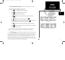
3. Use
K
and
O
to enter your present heading in the ‘hdg:’ field. If your installation
includes a fuel/air data computer, this will be displayed automatically. Press
E
.
4. Use
K
and
O
to enter your true air speed (TAS) in the ‘tas:’ field. If you have previously
calculated it using the density altitude/true air speed function it will be displayed as the
default. Press
E
. The wind direction and speed and the value of the head/tail wind will
be displayed.
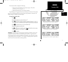
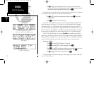
The GPS 150 will calculate vertical navigation requirements to achieve a certain altitude
before or after a waypoint. This is helpful when you would like to descend to a certain altitude
near an airport, or climb to a certain altitude before reaching a waypoint or NAVAID.
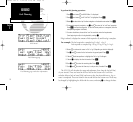
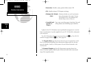
To calculate vertical navigation parameters:
1. Press
N
and rotate
O
until NAV Menu 1 is displayed.
2. Press
C
and rotate
O
until ‘Vnav Plan?’ is highlighted. Press
E.
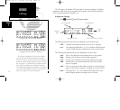
3. Use
K
and
O
to enter the initial (from) altitude. Your GPS altitude will be displayed
as the default. Press
E
.
4. Use
K
and
O
to enter the desired final (to) altitude. Press
E
.
5. Use
K
and
O
to enter the distance from the waypoint. Press
E
.
6. Use
K
to select ‘before’ or ‘after’ the waypoint. Press
E
.
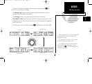
17
REFERENCE
Winds Aloft &
VNAV Calculations
Section
1
Winds Aloft page
NAV Menu 1
Vertical Navigation page
150man rev E 7/24/98 3:10 PM Page 17