


5
Introduction
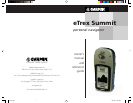
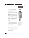
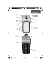
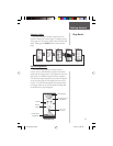
The eTrex Summit is a six ounce, 12 channel, hand
held GPS receiver. It has a built-in GPS antenna and only
fi ve user-Buttons. All Buttons are located on either side of
the unit, allowing for simple, one-handed operation that
won’t obstruct your view of the display. It runs for up to
22 hours on two AA batteries in battery save mode.
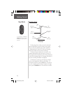
The eTrex Summit contains a full function GPS, elec-
tronic compass and barometric altimeter. The eTrex
Summit will track barometric pressure and altitude
changes, providing data never before available in such
a small package. Using the built in compass, the eTrex
Summit will provide you with a reliable heading even
while standing still. When moving, the eTrex Summit
will provide you with more data, including speed, direc-
tion of movement, time, distance to destination, and
more.
From these basic features, your eTrex Summit can
provide one more critical benefi t; peace of mind, because,
with the combination of these technologies you’ll know
where you are, where you’ve been and where you’re
going. And since you’ll always know the way back home,
you can concentrate on what you set out to do and enjoy
the great outdoors.
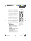
Other features include:
Waypoints:
500 with name and graphic symbol.
Tracks:
Automatic track log; 10 saved tracks.
Routes:
20 Routes that let you navigate through a set
of 50 waypoints.
Trip Computer:
Current speed, average speed, maxi-
mum speed, bearing, elevation, location, time of sunrise/
sunset, trip timer and trip odometer.
Elevation Computer:
Total ascent, total descent,
average ascent, average descent, maximum ascent,
maximum descent, vertical speed, pressure, 12 hour
pressure trend, maximum elevation, and minimum ele-
vation.
NOTE: You should always
be prepared and capable of
navigating without the eTrex
Summit. It is designed to aug-
ment other forms of basic nav-
igation, not entirely replace
them.
Features
190-00193-00_0D.indd 02/12/01, 10:07 AM5