


47
To change the Map Datum:
1. With the MENU Page displayed using the UP or
DOWN Button, highlight ‘SETUP’ and press ENTER.
2. Using the UP or DOWN Button select ‘UNITS’. Press
ENTER. The UNITS Page appears.
3. Using the UP or DOWN Button select the ‘MAP
DATUMS’ fi eld. Press ENTER.
4. Using the UP or DOWN Button to select the desired
datum. Press ENTER.
Distance/Speed Units
The eTrex Summit lets you select statute (the default
setting), nautical, or metric units of measure for all speed
and distance readouts.
To change the Distance/Speed units:
1. With the MENU Page displayed, use the UP or
DOWN Button to highlight ‘SETUP’ and press
ENTER.
2. Using the UP or DOWN Button select ‘UNITS’. Press
ENTER. The UNITS Page appears.
3. Using the UP or DOWN Button select the ‘UNITS’
fi eld. Press ENTER.
4. Press the UP or DOWN Button to select the desired
unit. Press ENTER. Press PAGE to select the page
of your choice.
Elevation/VSPD (vertical speed)
The eTrex Summit lets you select either feet or meters
for all elevation and vertical speed readings.
To Change the Elevation/VSPD Units:
1. With the MENU Page displayed using the UP or
DOWN Button highlight ‘SETUP’ and press ENTER.
2. Using the UP or DOWN Button select ‘UNITS’. Press
ENTER. The UNITS Page appears.
3. Using the UP or DOWN Button select the
‘ELEVATION/VSPD’ fi eld. Press ENTER.
4. Press the UP or DOWN Button to select ‘FEET’ or
‘METERS’. Press ENTER. Press PAGE to select the
page of your choice.
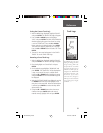
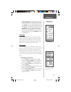
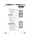
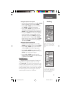
You can select statute, nautical,
or metric units of measurement
from the ‘UNITS’ page.
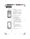
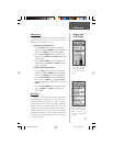
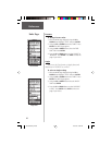
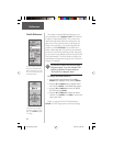
The ‘DEFAULTS’ setting will reset
the eTrex Summit units to all of its
factory settings.
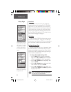
Units of Measure
Reference
190-00193-00_0D.indd 02/12/01, 10:09 AM47