


9
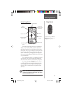
Getting Started
The Getting Started Section introduces you to the
basic operation of the eTrex Summit. The Reference Sec-
tion shows you how to use all of eTrex Summit’s remain-
ing features.
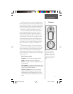
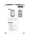
The First Step
The eTrex Summit’s GPS operates using information
gathered from satellites. To Initialize the eTrex Summit’s
GPS receiver the fi rst time, take your eTrex Summit out-
side and fi nd a large, open area that has a clear view of
the sky. Press and hold the POWER Button to turn the
unit on. You’ll see the Welcome Page for a few seconds
while the eTrex Summit performs a self-test, followed by
the SkyView Page.
NOTE: When you use the eTrex Summit for the
fi rst time, it will take up to fi ve minutes to fi nd
your location. After the fi rst use, eTrex Summit
only needs about 15 to 45 seconds to fi nd your
location.
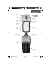
The eTrex Summit needs to receive at least three
strong satellite signals to fi nd your location. The SkyView
Page shows you graphically eTrex Summit tracking satel-
lites, and the strength of the satellite signals. The status is
also displayed at the top of the page.
When you see the “READY TO NAVIGATE” message
in the status box, eTrex Summit has found your location
and the GPS receiver is initialize and ready for use.
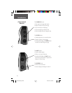
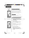
Backlighting and Contrast
If the lighting conditions make it hard for you to see
the screen, adjust the contrast or turn on the backlight.
Press and release the POWER Button from any screen to
turn on the backlight. The backlight is timed to stay on
for 30 seconds. To adjust the screen contrast, press the
PAGE Button until you see The SkyView Page. Press the
UP Button to make the screen darker, press the DOWN
Button to make the screen lighter.
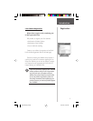
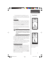
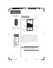
The SkyView Page
The “READY TO NAVIGATE”
message must appear before
you can begin using your eTrex
Summit to navigate.
F
Here We Go
190-00193-00_0D.indd 02/12/01, 10:08 AM9