


V
4.4.8 Marked map points (Pin) ..................................................................... 27
4.4.9 Visible POIs (Points of Interest) .......................................................... 28
4.4.10 Elements of the Active Route.............................................................. 29
4.4.10.1 The start point, via points and the destination.............................. 29
4.4.10.2 Animated turn guidance ............................................................... 29
4.4.10.3 The active leg of the route............................................................ 29
4.4.10.4 Inactive legs of the route.............................................................. 29
4.4.10.5 Roads in the route excluded by your preferences........................ 29
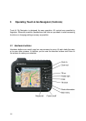
4.5 Screens with map..................................................................................... 30
4.5.1 Turn preview (No. 1) ........................................................................... 31
4.5.2 Zoom in and out (No. 2 & 3)................................................................ 31
4.5.3 Tilt up and down (No. 4 & 5)................................................................ 32
4.5.4 Lock to GPS position and heading (No. 6) .......................................... 32
4.5.5 Cursor (No. 7) ..................................................................................... 33
4.5.6 Map scale (No. 8)................................................................................ 33
4.5.7 Menu (No. 9) ....................................................................................... 34
4.5.8 Map orientation and Overview (No. 10)............................................... 34
4.5.9 GPS position quality (No. 11).............................................................. 35
4.5.10 Battery status (No. 12) ........................................................................ 35
4.5.11 Sound muting (No. 13) ........................................................................ 35
4.5.12 Track Log recording/playback indicator (No. 14)................................. 36
4.5.13 Cursor menu (No. 15) ......................................................................... 36
4.5.14 Current street (No. 16) ........................................................................ 38
4.5.15 Travel and Route data (No. 17)........................................................... 38
4.5.16 Distance to next turn (No. 18) ............................................................. 39
4.5.17 Next street / Next settlement (No. 19)................................................. 39
4.5.18 Approaching next turn (No. 20) ........................................................... 39
4.6 Route Information screen........................................................................ 39
4.6.1 Route data displayed (for destination and via points).......................... 40
4.6.1.1 Route line..................................................................................... 40
4.6.1.2 Distance Left................................................................................ 40
4.6.1.3 Method......................................................................................... 40
4.6.1.4 Time Left...................................................................................... 41
4.6.1.5 Estimated Arrival.......................................................................... 41
4.6.1.6 Destination / Via point .................................................................. 41
4.6.2 Warning icons ..................................................................................... 41
4.6.3 Fit to screen ........................................................................................ 42
4.6.4 Parameters.......................................................................................... 43
4.7 Menu.......................................................................................................... 43
4.7.1 Find tab ............................................................................................... 43
4.7.2 Quick tab............................................................................................. 43
4.7.2.1 3D Map ........................................................................................ 43
4.7.2.2 Zoom & Tilt................................................................................... 44
4.7.2.3 Night Mode................................................................................... 44
4.7.2.4 Manage POI (Points of Interest)................................................... 44
4.7.2.5 Popup Info.................................................................................... 47
4.7.2.6 Manage Track Logs ..................................................................... 47
4.7.3 Route tab ............................................................................................ 50
4.7.3.1 Recalculate .................................................................................. 50
4.7.3.2 Delete........................................................................................... 51