


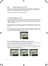
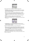

4.6.1.5 Estimated Arrival
This is an estimated value that can also be displayed in one of the Route data fields
on the Cockpit screen as ‘ETA to destination’. It shows the estimated arrival time at
the final destination of the route based on information available for the remaining
segments of the route. The calculation cannot take into account traffic jams and
other possible delays.
If via points exist, tap and tap again any of the fields to see the estimated arrival at
the first, second, etc. via point.
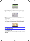
4.6.1.6 Destination / Via point
This field shows the exact address (or its coordinates if the address is not available)
of the final destination.
If via points exist, tap and tap again any of the fields to see the address or
coordinates of the first, second, etc. via point.
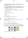
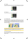
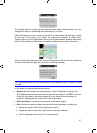
4.6.2 Warning icons
The following 5 squares are normally grey. Some of them turn red and show a
graphical symbol in case warning(s) are attached to the planned route. These are
warnings, so icons always show information for the whole route, even if the data
fields display values from your current position to a via point only.
Click on any of the icons to show its description.
A few samples of the available icons:
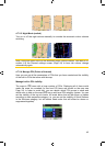
x
This icon shows that you need to pay toll on the recommended route.
x
This icon shows that the route contains motorways. Tap the icon to see the
total length of the motorways in the recommended route.
x This icon shows that toll roads are included in the recommended route.
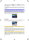
x This icon shows that you need to board a ferry along the recommended
route.
x This icon shows that you need to pay for the ferry.
x This icon is displayed when iGO could not plan a route with all your road
type preferences respected. Sometimes it is impossible to find a suitable route
near the start or the destination.
40
GNS