


42 Trail Guide
™
Owner’s Manual
E
N
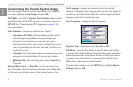
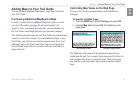
UNDERSTANDING GPS > THE GPS INFORMATION PAGE
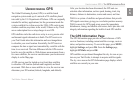
A signal strength bar appears for each satellite in view; the
satellite’s number (1–33) appears to the left of each bar. The
progress of satellite acquisition is shown in three stages:
• No signal strength bar—the GPS receiver is looking for
the satellite indicated. The corresponding number on the sky
view is not highlighted.
• Hollow signal strength bar—the GPS receiver has found
the satellite and is collecting data. The corresponding
number on the sky view is not highlighted.
• Solid signal strength bar—the GPS receiver has collected
the necessary data and the satellite is ready for use. The
corresponding number on the sky view is highlighted.
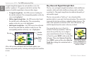
Satellites
Sky view
Signal
strength
bars
Satellite
status bar
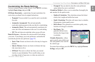
After a fix has been calculated, the Trail Guide updates your
location and ground speed by selecting and using the best satellites
in view.
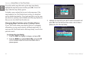
Sky View and Signal Strength Bars
The sky view and signal strength bars indicate which satellites are
currently visible and which satellites are being used to calculate
a position fix. The signal strength bars also indicate the quality of
each satellite signal.
The sky view provides a “bird’s eye” view of each satellite
position relative to your unit’s last known location. The outer circle
represents the horizon and shows cardinal heading references. The
inner circle represents an elevation of 45° above the horizon. Any
satellite depicted near the center is directly overhead.
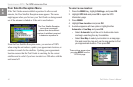
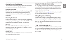
You can set the sky view to Track Up
instead of North Up orientation. Track Up
causes the top of the sky view to align to
your current direction of travel. To change
to Track Up, press MENU while on the GPS
Info page. Then select Skyview Track Up.
Press MENU again and then select Skyview
North Up to change the orientation back to
North Up.
When the Sky View is
shown in North Up, the
red circle indicates your
direction of travel.