


Trail Guide
™
Owner’s Manual 41
E
N
UNDERSTANDING GPS > THE GPS INFORMATION PAGE
UNDERSTANDING GPS
The Global Positioning System (GPS) is a satellite-based
navigation system made up of a network of 24 satellites placed
into orbit by the U.S. Department of Defense. GPS was originally
intended for military applications, but the government made the
system available for civilian use in the 1980s. GPS works in any
weather condition, anywhere in the world, 24 hours a day. There
are no subscription fees or setup charges to use GPS.
GPS satellites circle the earth twice a day in a very precise orbit
and transmit signal information to Earth. The GPS receiver in
your Trail Guide takes this information and uses triangulation
to calculate your exact location. Essentially, the GPS receiver
compares the time a signal was transmitted by a satellite with the
time it was received. The time difference tells the GPS receiver
how far away the satellite is. With distance measurements from a
few more satellites, the receiver can determine your location and
display it on the Map page.
A GPS receiver must be locked on to at least three satellites
to calculate a 2D location (latitude and longitude) and track
movement. With four or more satellites in view, the receiver can
determine your 3D location (latitude, longitude, and altitude).
After your location has been determined, the GPS unit can
calculate other information, such as speed, bearing, track, trip
distance, distance to destination, sunrise and sunset, and time.
WAAS is a system of satellites and ground stations that provide
GPS signal corrections, giving you even better position accuracy.
WAAS corrects for GPS signal errors caused by ionospheric
disturbances, timing, and satellite orbit errors, and it provides vital
integrity information regarding the health of each GPS satellite.
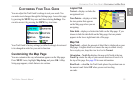
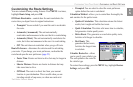
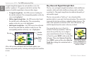
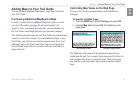
The GPS Information Page
The GPS Information page provides a visual reference of GPS
receiver functions, including current satellite coverage, receiver
status, and position accuracy. To access this page, press MENU,
highlight Settings, and press OK. From the Settings page,
highlight GPS Info and press OK.
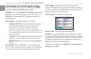
GPS satellites are positioned throughout the sky. As soon as you
turn on your Trail Guide, it attempts to acquire satellite signals.
The sky view area on the GPS Information page displays which
satellites are currently in your area.