


52
Reference
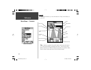
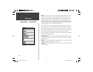
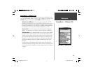
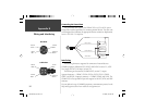
Setup Menu — ‘Location’ Tab
The ‘Location’ Tab contains the settings for ‘Location Format’, ‘Map Datum’,
‘North Reference’ and ‘Magnetic Variation’. The settings are used in related fi elds
throughout the unit.
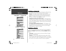
‘ Location Format’ —
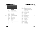
There are 28 different formats to choose from. See the
sidebar for a list of the formats. You should not need to change the format
unless you are using a chart or paper map for navigation. If so, fi nd the
format that most closely matches your chart or map.
‘ Map Datum’ —
Datums are used to describe geographic positions for
surveying, mapping, and navigation and are not actual maps built in the unit.
Although there are over 100 datums available to choose from, you should
only need to change the Map Datum if you using a chart or paper map that
specifi es a different datum in the legend. A list of Map Datums can be found
in Appendix D.
WARNING: Selecting the wrong map datum can result in substantial
position errors. When in doubt, use the default WGS 84 datum for
best overall performance.
‘ North Reference’ —
Let’s you select the reference used in calculating
heading information. You can select from, ‘Auto’ ‘True’, ‘Magnetic’, ‘Grid’ or
‘User’. ‘Auto’ provides magnetic north heading references which are automati-
cally determined from your current location. ‘True’ provides headings based
upon a true north reference. ‘Grid’ provides headings based on a grid north
reference (used in conjunction with the grid location formats described on
page 56). ‘User’ allows you to specify the magnetic variation at your current
location, and provides magnetic north heading references based on the value
you entered.
hddd.ddddd°
hddd°.mm.mmm’
hddd°.mm’ss.s’’
British Grid
Dutch Grid
Finnish Grid
German Grid
India Zone 0
India Zone IA
India Zone IB
India Zone IIA
India Zone IIB
India Zone IIIA
India Zone IIIB
India Zone IVA
India Zone IVB
Irish Grid
LORAN TD
Maidenhead
MGRS
New Zealand
QNG Grid
RT 90
Swedish Grid
Swiss Grid
Taiwan Grid
UTM UPS
W Malayan RSO
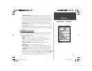
User UTM Grid
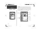
Location Formats
The ‘User UTM Grid’ will let the user defi ne a grid for a
location format. The user will have to know the Longitude
Origin, Scale, False Easting, and False Northing to create
the grid.
For more information on grids and datums, we recommend
that you visit the National Imagery and Mapping Agency at
http://www.nima.mil
User UTM Grid
Setup Menu — Location Tab
190-00249-00_0C.indd 52 5/7/2003, 9:54:58 AM