


9
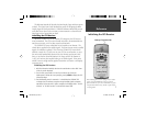
Getting Started
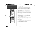
Speed, GPS Elevation and Estimated Accuracy
When the GPS is receiving at least three satellite signals, it will provide you
with the current GPS Speed, DGPS Status, and the estimated Accuracy of the GPS
Location. The GPS must be receiving at least four satellite signals to report GPS
Elevation.
Current GPS
Receiver Status
The current status of the GPS receiver will always be displayed.
Autolocate —
Forces the receiver to search for each satellite individually.
Acquiring Satellites —
The receiver will begin in this mode each time the
unit is turned on. The GPS receiver will remain in this mode until it has
acquired at least 3 satellite signals.
2D GPS Location —
Indicates that the receiver is only using three satellite sig-
nals. When a 2D GPS Location is achieved, the GPS will display your current
position but is incapable of providing an altitude reading.
3D GPS Location —
Indicates the receiver is currently using at least four
satellite signals and is capable of providing your current position and altitude.
2D Differential Location —
Indicates the receiver is using DGPS or WAAS
differential data on three satellites.
3D Differential Location —
Indicates the receiver is using DGPS or WAAS
differential data on at least four satellites.
Lost Satellite Reception —
Indicates that the GPS has lost satellite reception.
Simulating GPS
— Indicates the GPSMAP 76S is running in Simulator Mode
and the GPS receiver is turned off. It is important to remember when you are
using the Simulator, the GPSMAP 76S can not be used for actual navigation.
GPS Off
— Indicates that the GPS receiver is turned off.
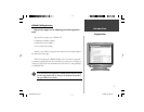
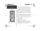
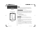
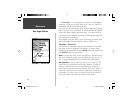
Satellite
Signal
Strength
Location
Time
Date
Receiver
Status
Satellite
Location
GPS Information Page
GPS Information Page
Data Fields
Reference
190-00249-00_0C.indd 9 5/7/2003, 9:54:35 AM