


12
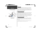
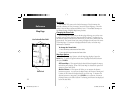
Map Page
The GPSMAP 76S comes with a built-in basemap of North America that
includes a database of Cities, Interstate, State and County Highways, Exit infor-
mation, Lake and River outlines and Railway Lines. The standard basemap can
be enhanced using GARMIN’s MapSource products.
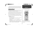
Changing the Zoom Scale
You can change the Zoom Scale on the Map Page allowing you to either view
a smaller area in greater detail or a larger area with less detail. As referred to in
this manual, when you decrease the Zoom Scale you will view a smaller area with
greater detail. The current Zoom Scale setting is displayed in the lower left corner
of the Map Page. If ‘ Overzoom’ is displayed under the scale, no further map
information is available.
To change the Zoom Scale:
1. Press the IN Key to decrease the Zoom Scale.
2. Press the OUT Key to increase the Zoom Scale.
Map Page Options
To access the Map Page Options, with the Map Page displayed, press the
MENU Key. To select an option from the Menu, highlight the desired selection
then press ENTER.
Full Screen Map —
This option hides the data fi elds and expands the map to
include the entire display. When ‘Full Screen Map’ is selected the option will
change to ‘Show Data Fields’.
Measure Distance —
This option will allow you to measure the distance
between two points. As you move the Map Pointer, the Distance, Bearing and
Location of the Pointer are displayed at the top of the map. To measure the
distance between to map points, press ENTER to set a reference, then move
the Map Pointer to the other location. The Bearing, and Distance are displayed
below the data fi elds.
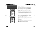
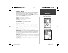
Zoom Scale
User Selectable Data Fields
Map Page
Reference
190-00249-00_0C.indd 12 5/7/2003, 9:54:37 AM