


10
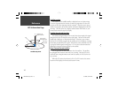
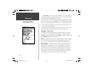
Satellite Location
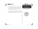
The location of each available satellite is displayed over two location rings.
The outer ring represents the horizon, the inner ring represents 45° above the
horizon and the center represents directly overhead. When the unit is using a
satellite for navigation, the satellite number will become highlighted on the loca-
tion rings. The unit can be set to display satellite location with North, or your
current track toward the top of the display.
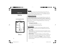
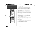
Satellite Strength Indicator Bars
The Satellite Strength Indicator Bars not only show the strength of the signal
being received, they also show the status of the signal. The bars will be either
shaded with a light grey, or fi lled with solid black. If the bar is grey, it means
that the GPS is receiving a signal from the satellite and is in the process of storing
orbital data provided in the GPS signal. When the bar turns solid black, the GPS
is using the satellite signal for navigation. A “D” in or above the bar means that
differential corrections are being applied to that satellite.
Date, Time and Current Location
The GPS gets date and time information from the satellites. The satellites
are equipped with an atomic clock that is very accurate. Since the GPS clock
is derived from timing information sent from the satellite, the GPS clock is also
very accurate.
When the GPS receiver has achieved a 2D or 3D GPS Location, the current
location will be displayed in the selected Location Format.
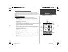
Satellite Sky View
GPS Information Page
45°
90°
Outer ring-
the horizon
Inner ring-45°
above thehorizon
Center dot- 90°
above thehorizon
Reference
190-00249-00_0C.indd 10 5/7/2003, 9:54:35 AM