


30
Reference
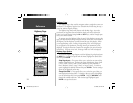
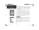
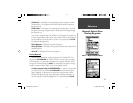
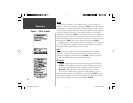
Track Information Page
Points Page
Show on Map and Highway
— when checked, will allow the Saved Track to
be displayed on the Map and Highway Pages.
Elevation Plot —
the ‘Elevation Plot’ button will show the Elevation Plot for
the saved track on the Plot Page.
Delete Button —
if the ‘Delete’ Button is selected, you will be prompted to
verify you want to delete the Saved Track.
Map Button —
will display the Saved Track on the Map Page.
TracBack Button —
will initiate TracBack Navigation. TracBack Navigation
uses Track Points in a saved track to automatically create a route. You will
have the option of navigating the route in the ‘Original’ or ‘Reverse’ direction.
OK Button —
saves any changes and returns the display to the Tracks Page.
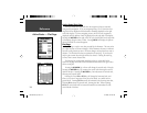
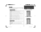
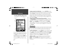
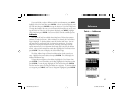
Points Page
The Points Page allow you to select Waypoints, Points of Interest, Cities, Exits,
Addresses, and Intersections using your current location or a location on the
map. To select a Point item, highlight the desired selection then press ENTER.
Waypoints
When ‘Waypoints’ is selected, a user waypoint list will displayed. This list
can be displayed as ‘Waypoints by Name’, or by ‘Nearest Waypoints’. With the
waypoint list displayed, pressing the MENU Key will display an Options Menu.
Waypoint Options Menu
Find By Name / Find Nearest —
This option allows you to select how the
Waypoint List will be displayed. When ‘ Find Nearest’ is currently selected,
‘Find by Name’ will be displayed in the options menu.
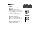
Track Information Page
TIP:
If you know that you are going to want to use the
TracBack feature for a return trip, clear the Track Log
before you start the trip. This will ensure that you are
only navigating along the most recent Track.
190-00249-00_0C.indd 30 5/7/2003, 9:54:47 AM