


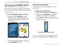

GPSMAP 76CSx Owner’s Manual iii
INTRODUCTION > TABLE OF CONTENTS
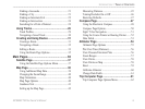
Finding a Geocache ..............................................21
Finding a City .......................................................21
Finding an Interstate Exit .....................................22
Finding an Intersection .........................................24
Searching for a Point of Interest ...........................24
Using Tracks .....................................................26
Track Profiles ........................................................29
Navigating a Saved Track .....................................30
Creating and Using Routes .............................31
Creating a Route ...................................................31
Navigating a Route ...............................................32
Editing a Route .....................................................33
Using the Route Page Options ..............................35
Main Pages .....................................................36
Satellite Page ....................................................37
Using the Satellite Page Options Menu ................37
Map Page ...........................................................38
Using Additional Map Data ..................................39
Changing the Zoom Range ...................................40
Map Orientation ....................................................40
Map Page Options ................................................40
Guidance Text .......................................................41
Setting up the Map Page .......................................42
Measuring Distance ..............................................45
Turning Declutter On or Off .................................46
Restoring Defaults ................................................47
Compass Page ..................................................47
Using the Electronic Compass ..............................48
Compass Page Options .........................................50
Sight ‘N Go Navigation ........................................51
Using the Course Pointer or Bearing Pointer .......52
Data Fields ............................................................53
Altimeter Page ..................................................54
Altimeter Page Options ........................................55
Plot Over Time (Distance) ....................................56
View Pressure/Elevation Plots .............................56
Zoom Ranges ........................................................57
View Points ...........................................................58
View Points on Map .............................................58
Reset .....................................................................59
Calibrate Altimeter ...............................................60
Change Data Fields ...............................................61
Trip Computer Page .........................................61
Trip Computer Page Options Menu ......................62