


GPSMAP 76CSx Owner’s Manual 91
APPENDIX > SPECIFICATIONS
APPENDIX
Specifications
Physical
Size: 6.2" H x 2.7" W x 1.4" D
Weight:
7.6 ounces (216 g) w/batteries installed.
Display: 1.5" W x 2.2" H, 256-color, high resolution,
transreflective (160 x 240 pixels) with backlighting.
Case: Rugged, fully gasketed, water resistant, IEC-529, IPX7
Temp Range:
5 to 158
o
F (-15 to 70
o
C)*
*The temperature rating of the GPSMAP 76CSx may exceed the usable range
of some batteries. Some batteries can rupture at high temperatures.
Performance
Receiver: WAAS enabled
Acquisition Times*:
Approx. 1 second (warm start)
Approx. 38 seconds (cold start)
Approx. 45 seconds (factory reset)
*On average for a stationary receiver with an open sky view.
Update Rate: 1/second, continuous
Antenna: Built-in quad helix, remote antenna capability.
Compass: Accuracy; +/- 5 degrees
1
, resolution; 1 degree
Altimeter: Accuracy; +/- 10 feet*, resolution; 1 ft.
*Subject to proper user calibration.
Power
Source: Two 1.5 volt AA batteries, USB power, 12 V Adapter
Cable, or up to 36 VDC external power
Battery Life: Up to 18 hours (typical use)*
*Alkaline batteries lose a significant amount of their capacity as the
temperature decreases. Use Lithium batteries when operating the GPSMAP
76CSx in below-freezing conditions. Extensive use of screen backlighting,
electronic compass, and audible tones significantly reduce battery life.
Accuracy
GPS: <10 meters (49 feet) 95% typical*
*Subject to accuracy degradation to 100m 2DRMS under the U.S. DoD
imposed Selective Availability (SA) Program when activated.
DGPS: 3-5 meters (10-16 feet) 95% typical*
*
WAAS accuracy in North America.
Velocity: 0.05 meter/sec steady state
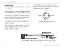
Interfaces: NMEA 0183 version 2.3, and RS-232 and USB for
PC interface
Data Storage Life: Indefinite: no memory battery required
Map Storage: Dependant on the formatted capacity of the
MicroSD Digital Card
(A small portion of the card capacity has been used in formatting the card for use.)