


39
Reference
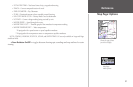
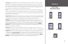
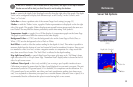
Sonar Tab Options
I
If the unit is unable to track the bottom for any reason, the digits in the depth window
flashes on and off to alert you that the unit is not tracking the bottom.
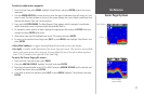
Scale — controls the depth ‘Scale’ displayed vertically along the right side of the graph. The depth
‘Scale’ can be configured to display four different ways: as an ‘Overlay’, in the ‘Corners’, with
‘Basic’, or ‘No Scale’.
Color Bar — shows a gradient scale of the current Target Level setting (see page 35).
Flasher — with the ‘Flasher’ active, a graphic Flasher representation is displayed on the far right
side of the graph. This graphic Flasher displays structure and bottom returns much the same as a
true Flasher. You may find this feature particularly useful when using ‘Fish Symbols’.
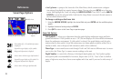
Temperature Graph — toggles On or Off the display of a temperature graph on the Sonar Page.
The graph is synchronized with the returns on the sonar display.
Background Color — (178C) sets the background color on the Sonar Page to Black, Blue, or
White. (178) sets the background color to Black or White.
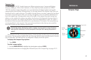
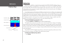
Keel Offset — used to offset the surface reading for the depth of a keel. This makes it possible to
measure depth from the bottom of your keel instead of from the transducer’s location. Enter a posi-
tive number to offset for a keel, or enter a negative number to compensate for a large vessel that
may draw several feet of water. The ‘Keel Offset’ is reflected in the depth reading.
Map Split Sonar Detail — controls Map/Sonar Page sonar split range scale. ‘Full Range’ shows
right side scale of 2X or 4X split Sonar Page. ‘Maximum Detail’ displays what is shown on the left
side of a split sonar screen.
Calibrate Water Speed — this is only available if you are using a speed-capable transducer/sensor.
Calibration is required to ensure that the Water Speed displayed on your unit is accurate. The unit
automatically uses the GPS ground speed, if it is available, for comparison on the calibration. If a
GPS ground speed is not available, use either your boat’s speedometer reading (not always accu-
rate), or a stopwatch to determine your speed over a certain distance (distance / time = speed). It is
recommended that the calibration take place in water having little or no current.
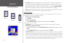
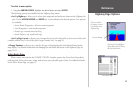
Main Menu—Sonar Tab
(172C)
Depth Scale (Overlay)
Color Bar
Flasher