


Garmin aera 795/796 Quick Reference Guide
190-01194-01 Rev. C
Appendix
52
OverviewGPS NavigationFlight PlanningHazard AvoidanceUtilitiesAppendixIndex
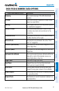
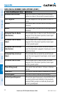
DATA FIELD & NUMERIC DATA OPTIONS (CONT.)
Data Field/Numeric Data Definition
Minimum Safe Altitude
Uses Grid MORAs to determine a safe altitude
within ten miles of the aircraft’s present position.
Next Waypoint
The next waypoint in the flight plan or direct-to
route.
Sunrise
The time at which the sun rises on this day (current
location).
Sunset
The time at which the sun sets on this day (current
location).
Estimated Time En Route
(Destination)
The estimated time it takes to reach the destination
waypoint from the present position, based upon
current ground speed.
Estimated Time En Route
(Next)
The estimated time it takes to reach the next
waypoint form the present position, based upon
current ground speed.
Estimated Time of Arrival
(Destination)
The estimated time at which the aircraft should
reach the destination waypoint, based upon current
speed and track.
Estimated Time of Arrival
(Next)
The estimated time at which the aircraft should
reach the next waypoint, based upon current speed
and track.
Estimated Time to VNAV
The estimated time it takes to reach the VNAV
waypoint form the present position, based upon
current ground speed.
Time of Day (Local)
The current time and date in 12-hour or 24-hour
format.
Time (UTC)
The current time and date in Universal (UTC) time.
Vertical Speed
The rate of climb or descent (GPS-derived).
Vertical Speed Required
The vertical speed necessary to decend/climb from
a current position and altitude to the previously
selected VNAV position and altitude, based upon
current groundspeed.