


Garmin aera 795/796 Quick Reference Guide
190-01194-01 Rev. C
15
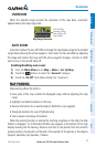
Overview
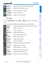
Overview GPS Navigation Flight Planning Hazard Avoidance Utilities Appendix Index
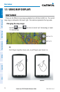
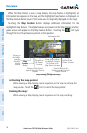
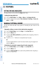
OVERZOOM
When the selected range exceeds the resolution of the map data, ‘overzoom’
appears below the map range scale.
Map Range/Overzoom
Scale Bar Rep-
resenting a Map
Scale of 3 nm Per
Scale Width.
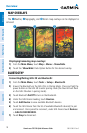
AUTO ZOOM
Auto Zoom allows the aera 795/796 to change the map display range to the smallest
range clearly showing the active waypoint. Auto Zoom can be overridden by adjusting
the range and remains that way until the active waypoint changes, a terrain or traffic
alert occurs, or the aircraft takes off.
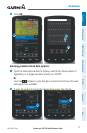
Enabling/disabling auto zoom:
1)
From the Main Menu, touch Map > Menu > Set Up Map.
2)
Touch the buttons to select the 'General' Category.
3)
Touch the 'On/Off' Data Option Button for 'Autozoom'.
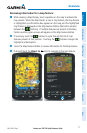
MAP PANNING
Map panning allows the pilot to:
•Viewpartsofthe mapoutsidethedisplayedrangewithoutadjustingthe map
range
•Highlightandselectlocationsonthemap
•Reviewinformationforaselectedairport,NAVAIDoruserwaypoint
•Designatelocationsforuseinightplanning
•Viewairspaceandairwayinformation
When the panning function is selected by touching anywhere on the Map, the Map
Pointer is displayed. An Information Window also appears at the bottom of the map
display showing the the bearing, distance and time to the pointer from the aircraft’s
present position, the elevation of the land at the position of the pointer, or the object’s
(airports, obstacles, etc) elevation, if known.