


Garmin aera 795/796 Quick Reference Guide
190-01194-01 Rev. C
Appendix
51
Overview GPS Navigation Flight Planning Hazard Avoidance Utilities Appendix Index
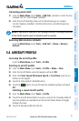
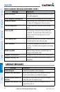
DATA FIELD & NUMERIC DATA OPTIONS
Data Field/Numeric Data Definition
Accuracy
The current accuracy of the GPS determined
location.
Altitude
The current altitude in geometric height above
Mean Sea Level (MSL).
Bearing
The compass direction from the present position
to a destination waypoint.
Course to Steer
The recommended direction to steer in order
to reduce cross-track error and return to the
course line.
Crosstrack Error
The distance the aircraft is off a desired course
in either direction, left or right.
Desired Track
The desired course between the active “from”
and “to” waypoints.
Distance (Destination)
The distance to the destination waypoint in the
Active Flight Plan
Distance (Next)
The distance to the next waypoint in the Active
Flight Plan.
En Route Safe Altitude
The recommended minimum altitude within ten
miles left or right of the desired course on a
active flight plan or direct-to.
Flight Timer
Total time in-flight (HH:MM).
Fuel Timer
Elapsed time since the Fuel Tank Reminder
Alarm was last issued (HH:MM).
Glide Ratio
The estimated distance an aircraft will move
forward for any given amount of lost altitude.
Ground Speed
The velocity that the aircraft is traveling relative
to a ground position.
Ground Track
The direction of aircraft movement relative to a
ground position.