


Garmin aera 795/796 Quick Reference Guide
190-01194-01 Rev. C
9
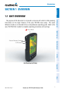
Overview
Overview GPS Navigation Flight Planning Hazard Avoidance Utilities Appendix Index
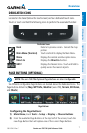
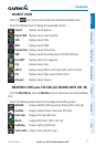
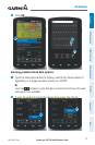
NEAREST ICONS
Touch the
icon at any time to access the second-level Nearest icons.
Touch the following icons to display the associated function:
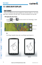
Airport Displays nearest airports.
Airport WX Displays nearest airport weather.
VOR Displays nearest VORs.
NDB Displays nearest NDBs.
Intersection Displays nearest intersections.
VRP Displays nearest Visual Reporting Point (VRP) (Atlantic).
User WPT Displays nearest user waypoints.
City Displays nearest cities.
ARTCC Displays nearest ARTCCs (Air Route Traffic Control Centers).
FSS Displays nearest Flight Service Stations (FSS).
Airspace Displays nearest airspace.
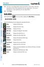
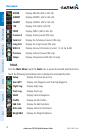
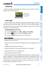
WEATHER ICONS (aera 796 XM) (ALL MODELS WITH GDL 39)
From the Main Menu, touch the
Weather icon to access the second-level Weather
Icons.
Touch the following second-level Icons to display the weather product:
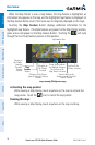
NEXRAD Displays NEXRAD (NEXt-generation RADar) (XM or GDL 39).
Satellite Displays Satellite Mosaic cloud cover (XM only).
Echo Tops Displays Echo Tops (XM only).
Winds Displays Winds Aloft. (XM or GDL 39).
Lightning Displays Lightning (XM only).
Storm Cells Displays Storm Cells (XM only).