


Garmin aera 795/796 Quick Reference Guide
190-01194-01 Rev. C
38
Hazard Avoidance
OverviewGPS NavigationFlight PlanningHazard AvoidanceUtilitiesAppendixIndex
Or:
1)
From the Main Menu touch the Weather Icon.
2)
Touch Menu > Information.
Viewing Ground Station Status:
1)
From the Main Menu touch the Tools Icon.
2)
Touch Data Link.
Or:
1)
From the Main Menu touch the Weather Icon.
2)
Touch Menu > Information.
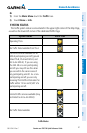
Viewing FIS-B Weather products on the Navigation Map:
1)
From the Main Menu touch the Map Icon.
2)
Touch the Menu Icon.
3)
Touch the 'Show/Hide...' menu option.
4)
Touch the Weather 'Show/Hide' Button.
Viewing FIS-B Weather products on the Weather Map:
1)
From the Main Menu touch the Weather Icon.
2)
Touch the desired second-level Weather Icon.
3)
If necessary, touch the buttons to scroll through the list of available
altitudes, or AIRMET types.
4)
Touch the desired weather product to get abbreviated information about
the selected weather product (if available).
5)
With the desired weather product highlighted, touch the Map Feature
Button to get detailed information (if available).
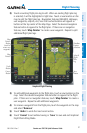
Animating FIS-B weather:
1)
From the Main Menu, touch the Map Icon (weather must be enabled).
Or:
a)
From the Main Menu, touch the Weather Icon.
b)
Touch the NEXRAD Icon.
2)
Touch the Menu Icon.
3)
Touch the 'Animate Weather' menu option.