


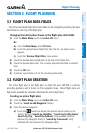

Garmin aera 795/796 Quick Reference Guide
190-01194-01 Rev. C
31
Flight Planning
Overview GPS Navigation Flight Planning Hazard Avoidance Utilities Appendix Index
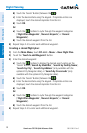
2)
Touch an existing flight plan leg to edit. When an existing flight plan leg
is selected, it will be highlighted in light blue. Touch a new location on the
map to split the flight plan leg. Navigation features (NAVAIDS, Highways,
user waypoints, airports, etc.) near the touched location will appear as
buttons at the top center of the Map Page. Select the desired navigation
feature button to append to the flight plan. If there are no navigation
features, touch 'Map Pointer' to create a user waypoint. Repeat to split
additional flight plan legs.
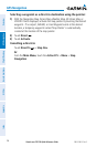
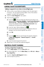
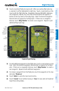
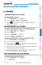
Graphical Flight Planning
Save
Button
Database
Feature
Selections
Map
Pointer
Button
(touch to
create user
waypoint)
Undo
Button
Cancel
Button
Map
Pointer
Selected
Flight
Plan
Leg
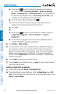
3)
To add additional waypoints to the flight plan, touch a new location on the
map. Select the desired navigation feature button to append to the flight
plan. If there are no navigation features, touch 'Map Pointer' to create a
user waypoint. Repeat to add additional waypoints.
4)
To remove a waypoint from the flight plan, touch the waypoint on the map
and select 'Remove'.
5)
Touch 'Undo' to undo the most recent action.
6)
Touch 'Cancel' to exit without saving or 'Save' to save and exit Graphical
Flight Plan Editing Mode.