


Garmin aera 795/796 Quick Reference Guide
190-01194-01 Rev. C
43
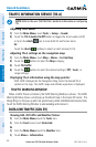
Hazard Avoidance
Overview GPS Navigation Flight Planning Hazard Avoidance Utilities Appendix Index
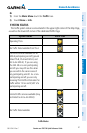
Enabling/Disabling Flight ID Display:
On
the Traffic Page, select
Menu > Disable/Enable Target Identifiers
.
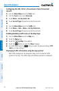
Changing the altitude range:
1)
On the Traffic Page, select the
Menu > Altitude Filter
.
2)
Select one of the following:
•
Unrestricted: All traffic is displayed.
•
Normal: Displays non-threat and proximity traffic from 2700 feet
above the aircraft to 2700 feet below the aircraft. Typically used during
enroute phase of flight.
•
Above: Displays non-threat and proximity traffic from 9000 feet
above the aircraft to 2700 feet below the aircraft. Typically used during
climb phase of flight.
•
Below: Displays non-threat and proximity traffic from 2700 feet
above the aircraft to 9000 feet below the aircraft. Typically used during
descent phase of flight.