


GPSMAP 182/182C Owner’s Manual 41
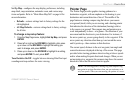
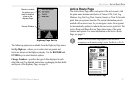
MAIN MENU > GPS TAB
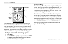
WAAS Capability
The GPSMAP 182/182C is capable of receiving WAAS (Wide
Area Augmentation System) satellite signals. WAAS is an FAA
(Federal Aviation Administration) funded project to improve the
overall accuracy and integrity of the GPS signal for aviation use,
but land/sea based users can also benefit from this system. At this
time, the system is still in the development stage and is not fully
operational.
There are currently two WAAS satellites that can be received in
the U.S.A., one over the Atlantic Ocean and one over the Pacific
Ocean, in a geo-stationary orbit over the equator. Effective use
of the WAAS satellite signal may be limited by your geographic
location in relation to those satellites, now in developmental
service. WAAS satellite signal reception requires an absolute
clear view of the sky and works best when there are no nearby
obstructions such as buildings and mountains.
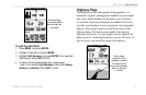
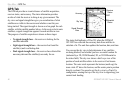
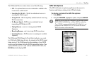
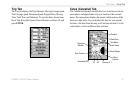
WAAS satellites are numbered 33 or higher when viewing the sky
view on your GPSMAP 182/182C. Initial reception of the WAAS
signal can take up to 15-20 minutes, then 1-2 minutes afterwards.
When WAAS differential correction has been received for GPS
satellites (numbers 32 or below), a D appears in the signal bar of
the sky view and 2D or 3D Differential appears in the receiver
status. To learn more about the WAAS system, its satellite positions
and current state of development, visit the FAA web site
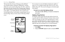
(http://gps.faa.gov). Because WAAS requires CPU resources of the
GPSMAP 182/182C to search for and track the satellites, you can
disable the WAAS feature to improve unit performance if WAAS
reception is not available in your area. Refer to the “Appendix” for
more information.