


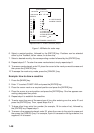
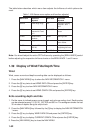

1-48
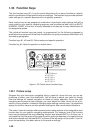
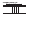
01 11 21 LINE CHANGE
02 12 22 MARK CANCEL
03 13
04 14
05 15
06 16 NAV LINE
07 17 COAST LINE
08 X 18 CONTOUR LINE
09 19 PROHIBITED AREAS
10 20 CABLE
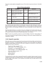
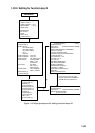
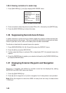
CANCEL ENTER MARK: CANCEL KEY
[ENTER MARK]
00°00.000 N/S 5-N 6-S
000°00.000 E/W 7-E 8-W
MARK 01
*
* Appears when L/L mode is selected (step 3).
Figure 1-46 Marks for radar map
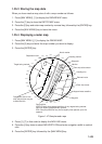
6. Select a wanted position, followed by the [ENTER] key. Positions can be selected
either by the Trackball, lat/lon values, or at own ship.
7. Select a desired mark by the corresponding number followed by the [ENTER] key.
8. Repeat steps 6-7. To enter the same mark selected, simply repeat step 6.
9. To erase a mark entered, enter 22, place the cursor to the mark you want to erase and
then press the [CANCEL] key.
10.To escape the mark entry mode, press the [CANCEL] key.
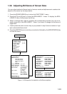
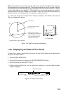
Example: How to draw a coastline
1. Press the [MARK] key.
2. Enter 17 to select COAST LINE and press the [ENTER] key.
3. Place the cursor mark on a required position and press the [ENTER] key.
4. Place the cursor at a next position and press the [ENTER] key. One line appears con-
necting designated two points.
5. Repeat step 4 to establish the coastline.
6. To enter more than one of the same type of line, after entering one line, enter 21 and
press the [ENTER] key. Then, repeat steps 2 to 5.
7. To draw other lines, enter line number (for example, 18 for contour line), followed by
the [ENTER] key. Repeat step 3.
8. To erase a line segment entered, enter 22, place the cursor to the point to erase and
then press the [CANCEL] key. For example, if point 4 is erased on the figure below, line
segment 3-4 is erased.