


6-4
6.4 Set-up of Video Plotter Display
6.4.1 Hiding/Showing graphics
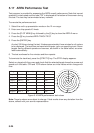
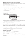
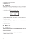
1. Press [NAV MENU], [8] to display the PLOT DISP SELECT menu. Current selections
appear in reverse video. Blank items have been turned off on the VIDEO PLOTTER
INITIAL SETTING menu. For further details see paragraph 6.10 Initial Settings.
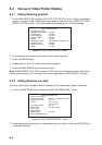
[PLOT DISP SELECT]
1 [VIDEO PLOTTER 1]
2 DANGER HIGHLIGHT OFF/ON
3 COAST LINE OFF/ON
4 LAND DENSITY OFF/ON
5 PLACE NAME OFF/ON
6 MARK OFF/ON
7 OWN SHIP PLOT OFF/SEPARATE/CONTINUE
8 TARGET PLOT OFF/ON
9 CONTOUR LINE OFF/ON
0 GRID OFF/ON
Figure 6-3 PLOT DISP SELECT menu
2. Press appropriate numeral key twice to hide or show graphic.
3. Press the [ENTER] key.
4. Repeat steps 2 and 3 to hide or show other graphics.
5. Press the [NAV MENU] key to close the menu.
Note: LAND DENSITY fills (ON) or hollows (OFF) land on an electronic chart. Land will be
hollow when wrong card or wrong scale is used regardless of LAND DENSITY setting.
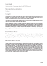
6.4.2 Hiding/Showing nav data
You may select what navigation data to display on the video plotter display as follows:
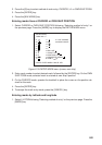
1. Press the [NAV MENU] key to display the NAV INFORMATION 1 menu.
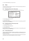
[NAV INFORMATION 1]
1 [VIDEO PLOTTER 1]
2 SELECT NAVAID GPS+LC/DEAD RECKONING
3 OWN SHIP POSN OFF/ L/L
4 POSN xx°xx.xxx N/S
xx°xx.xxx E/S
5 +CURSOR DATA OFF/ L/L
6 WPT DATA OFF/REL/TRUE
7 [NAV LINE]
8 [WAYPOINT]
9 WIND DATA OFF/ON
0 [NAV INFORMATION 2]
Figure 6-4 NAV INFORMATION 1 menu
2. Press appropriate numeral key to select both item and option. Press the [ENTER] key
to register selection.