


1-47
Notes on radar map operation
1) Own ship position display requires an input from radionavigational equipment such as
a GPS receiver in accordance with the data format as defined by IEC 61162-1.
2) Wind, water current, depth, water temperature are not displayed when relevant sen-
sors are not fitted.
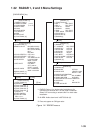
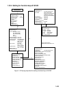
1.35.2 Making a radar map
1. Press the [NAV MENU] key to display the NAV INFORMATION 1 menu.
2. Press the [1] key to display the RADAR MAP menu.
3. Press the [2] key twice to set MAP ON, then press the [ENTER] key.
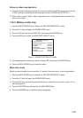
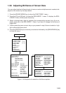
4. Press the [8] key to select the MAP DISP SELECT menu.
[MAP DISP SELECT]
1 [RADAR MAP]
2 DANGER HIGHLIGHT OFF/ON
3 COAST LINE OFF/ON
4 MARK OFF/ON
5 NAV LINE OFF/ON
6 PROHIBITED AREAS OFF/ON
7 BUOY OFF/ON
8 CONTOUR LINE OFF/ON
Figure 1-45 MAP DISP SELECT menu
5. Press appropriate numeric key twice to select ON, then press the [ENTER] key.
6. Press the [NAV MENU] key to close the menu.
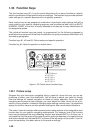
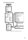
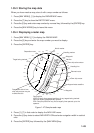
Mark entry mode
Marks can be entered by cursor position, L/L position (manual entry), or own ship position.
1. Press the [NAV MENU] key to display the NAV INFORMATION 1 menu.
2. Press the [1] key to display the RADAR MAP menu.
3. Press the [6] key and further press the [6] key to select the entry mode; cursor, L/L or
own ship position.
4. Press the [ENTER] key followed by the [NAV MENU] key.
5. Press the [MARK] key to read the following legends.