


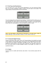

5.2.1 Daylight / Night colour profile
Clarion comes with different colour schemes for both daylight and night use. There is
always one selected daytime scheme and one selected night-time scheme. Clarion
uses these when switching from day to night and back.
Tap the appropriate button and select a new scheme from the list.
5.2.2 Alternative Road Names
Some highways have an international name or number for foreign travellers. You can
decide whether to show only the local name or both.
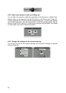
5.2.3 Show Street Labels
You can set whether or not to see the names of the streets and the POI icons on the
map when driving. Based on the current zoom and tilt levels, street names are
displayed either aligned with the street or on signposts stuck into the streets (Page
20). If you switch these signs on, it will be easier to recognise your location on the
map, if you turn them off, it will be easier to see the road geometry.
Note: You can only disable street names and POI icons if Clarion follows your
position. As soon as you move the map and Lock-to-Position (Page ) is disabled,
street names and icons become visible again. Tap Lock to re-enable Lock-to-
Position and have the labels and icons disappear again.
32
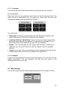
5.2.4 Textured Polygons
Enable textured polygons, and have rivers, lakes, forests and other large objects
displayed in a more realistic and attractive way on the map.
Disabling it will lead to uniform areas but better performance. See Page . 21
5.3 Sound settings
Settings on this page determine the way Clarion sounds.
66