


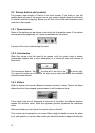
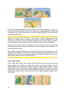
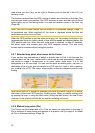

It is easy to change between 2D and 3D modes. You have two options. You can use
the Tilt up and down buttons (Page ) to tilt the map seamlessly between 2D and all
3D angles, or you can use the switch in the Quick menu (Page
31
43) to quickly switch
between the two modes.
Note: You may find that 2D mode is more useful in North-up Map mode when
looking for a certain part of the map or an object to select as destination. On the
other hand, 3D mode in Track-up Cockpit mode with Smart Zoom makes navigation
very comfortable. The description of these modes will come later in this manual.
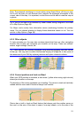
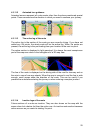
Note: 3D view is only useful for navigation. As you zoom out, the view angle will
automatically be raised. Finally 2D view will be reached. When you zoom back in, 3D
view will gradually return.
Note: Using the Advanced settings, you can force Cockpit mode to always start in 3D
Track-up view (Page ). You can still rotate and tilt the maps in either mode, but the
next time you enter this screen, the preset look will reappear. Similarly you can force
Map mode to always start in 2D North-up view.
72
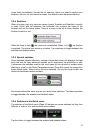
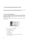
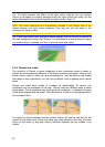
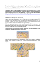
4.3.2 Zoom levels
Clarion uses high quality vector maps that let you see the map at various zoom
levels, always with optimised content (the density of the map details can be
independently set for Map and Cockpit screens in Map settings (Page )). Street
names and other text objects are always displayed with the same font size, never
upside down, and you only see as many streets and objects as needed to find your
way around the map. Zoom in and out to see how the map changes in either the 2D
or 3D view.
18