


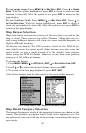


89
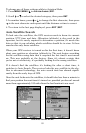
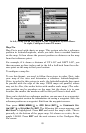
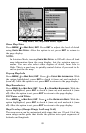
Map Menu, left, Map Data Menu, right.
Show Map Data
Press
MENU|↓ to MAP DATA|ENT. Press ENT to adjust the level of detail
using
EARTH MAP DETAIL. After the option is set, press EXIT to return to
the page display.
NOTE:
In Aviation Mode, turning
EARTH MAP DETAIL to Off will clear all land
map information from the map display, but the aviation map re-
mains. You can also select other degrees of detail, from Low to
High. This is a good way to quickly control clutter if you need to fo-
cus on just the air map.
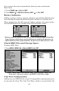
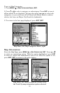
Pop-up Map Info
Press
MENU|↓ to MAP DATA|ENT. Press ↓ to POPUP MAP INFORMATION. With
the option highlighted, press
ENT to check it (turn on) and uncheck it
(turn off). After the option is set, press
EXIT to return to the page display.
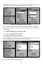
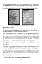
Map Boundaries
Press
MENU|↓ to MAP DATA|ENT. Press ↓ to DRAW MAP BOUNDARIES. With the
option highlighted, press
ENT to check it (turn on) and uncheck it (turn
off). After the option is set, press
EXIT to return to the page display.
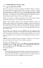
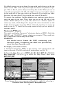
Fill Water with White
Press
MENU|↓ to MAP DATA|ENT. Press ↓ to FILL WATER WITH WHITE. With the
option highlighted, press
ENT to check it (turn on) and uncheck it (turn
off). After the option is set, press
EXIT to return to the page display.
Map Overlays (Range Rings; Lat/Long Grid)
The map screen can be customized with rings that are 1/2 and 1/4 of the
zoom range and/or grids that divide the plotter into equal segments of
latitude and longitude.