


50
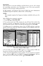
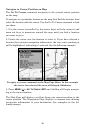
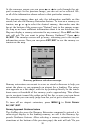
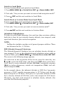
At the runways screen you can press ← or → to cycle through the air-
port's runways. In the previous image, you can see we've selected 18L,
so all of the information shown refers to that particular runway.
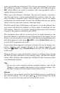
The previous images show not only the information available on this
screen, but also the Runway Extension feature. To turn on a runway ex-
tension, use ← or → to select the desired runway, then make sure the
box at the bottom of the screen says "Extend" next to the runway name.
(As long as we have sufficient information about it in our database, Air-
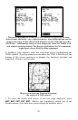
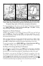
Map can display a runway extension for any runway.) Press
ENT and the
unit will ask "Do you want to setup Runway Guidance?" Press → to
NO|ENT. The runways screen will go away, returning you to the airport
information screen. Now you can press
EXIT|EXIT to see the runway ex-
tension on the map.
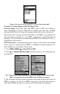
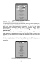
Runway guidance selection message.
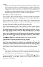
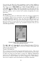
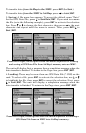
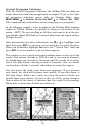
Runway extensions are meant to serve as visual references to help you
orient the plane as you approach an airport for a landing. The exten-
sion appears as a fan-shape, with its tip pointing directly to the touch-
down zone or threshold of the runway you're approaching. This allows
you to navigate toward the wider end of the fan, so once you turn down
the extension you can easily judge how far you've got to touch-down.
To turn off an airport extension, press
MENU|↓ to CLEAR RUNWAY
EXT|ENT|EXIT.
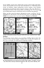
Runway Approach Guidance feature
The AirMap also uses the Runway Extension command to extend a lo-
calizer-type display to the landing runway; we call it the Runway Ap-
proach Guidance feature. After selecting a runway extension (see in-
structions at the bottom of the previous page) the unit will ask "Do you