


5
Com Port:........................One serial communications port, NMEA 0183
version 2.0 compatible. Allows exchange of
position data with another device, such as an
autopilot or personal computer. Optional
combination serial/power cable available.
Zoom range:.................... 40 ranges; 0.02 to 4,000 miles.
NOTE:
The above memory capacities refer only to AirMap's on-board mem-
ory. The amount of GPS data you can record and save for recall later
is only limited by the number of MMC cards you carry with you.
How AirMap Works
You'll navigate faster and easier if you understand how AirMap scans
the sky to tell you where you are on the earth — and, where you're go-
ing. (But if you already have a working understanding of GPS receivers
and the GPS navigation system, skip on ahead to Section 2, Installation
& Accessories on page 11. If you're new to GPS, read on, and you can
later impress your friends with your new-found knowledge.)
First, think of your AirMap as a small but powerful computer. (But
don't worry — we made AirMap so easy to use, you don't need to be a
computer expert to find your way!) The unit includes a keypad and a
screen with menus so you can tell AirMap what to do. The screen also
lets AirMap show your location on a moving map, as well as point the
way to your destination.
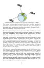
This "computer" also contains an antenna and specialized scanning re-
ceiver, something like your car radio. But instead of your favorite dance
tunes or VOR signals, this receiver tunes in to a couple of dozen GPS sat-
ellites circling the earth. (WAAS satellites, too, but more about them later.)
AirMap listens to signals from as many satellites as it can "see" above
the horizon, eliminates the weakest signals, then computes its location
in relation to those satellites. Once the AirMap figures its latitude and
longitude, it plots that position on the map shown on the screen. While
the screen is updated once a second the internal calculations are done
several times a second.
The performance doesn't stop there. Stored in the permanent memory
of each AirMap is a basic background map of the entire world. (For just
what's in the map, see the preceding segment on specifications.) We
lock it in here at the factory — you can't change or erase this map.
The background map, along with the Jeppesen and Lowrance aeronautical
databases, are all you need for aerial navigation. (Your unit reads these
databases automatically from the MMC card included in the package.)