


29
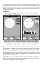
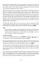
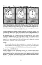
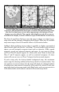
Following a course by "chasing the needle." Fig. 1, plane has veered off
course to the right by a little over 2 nautical miles, away from the nee-
dle. Fig. 2, pilot turns on heading of 332º, steering left toward CDI nee-
dle to intersect intended course. Fig. 3, pilot has intercepted his route
and is virtually on course.
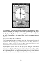
The most important graphic element, however, is the CDI needle. The
CDI and the cross track error scale instantly show you the distance to
the course line, as well as the direction to steer to get back on course. In
the example above, fig. 1 shows the pilot off course to the right, so the
CDI needle appears to the left of the plane symbol. Fig. 3 shows the pi-
lot back on course, so the CDI needle appears to line up with the course
arrow. If you steer toward the CDI needle line, you'll always be heading
in the correct direction to get back on course.
NOTE:
The examples above all show navigation to a waypoint, the most com-
mon method of GPS navigation. To show navigation from a waypoint,
see the instructions on the OBS Hold feature later in this section.
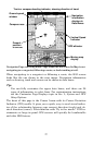
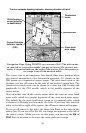
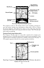
Navigating with OBS Hold
AirMap contains an OBS Hold feature to help you navigate along a pilot-
selected radial to or from a location. You must first turn on navigation to a
location before you can access OBS Hold. While running a route or navi-
gating to a waypoint, you launch OBS Hold from the Navigation Page;
just press the right or left arrow to initiate it.
Fig. 1
Fig. 2 Fig. 3
CDI needle
Course a
r
row
TO arrow