


24
No matter what page you are on, a flashing current position indica-
tor/question mark symbol and flashing GPS data displays indicate that
satellite lock has been lost and there is no position confirmed. This page
shows you the quality and accuracy of the current satellite lock-on and
position calculation.
WARNING:
Do not begin navigating with this unit until the numbers
have stopped flashing!
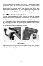
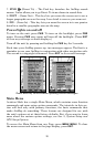
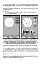
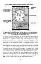
Satellite Page. Left view indicates unit has not locked on to any satellites
and does not have a fix on its positionRight view shows satellite-lock on
with a 3D position acquired (latitude, longitude and altitude) and WAAS
corrections. The bottom data box shows either a battery power indicator or
a voltage indicator, depending on what power source is being used.
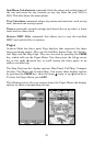
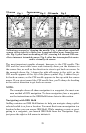
This screen shows a graphical view of the satellites that are in view.
Each satellite is shown on the circular chart relative to your position.
The point in the center of the chart is directly overhead. The small in-
ner ring represents 45° above the horizon and the large ring represents
the horizon. North is at the top of the screen. You can use this to see
which satellites are obstructed by obstacles in your immediate area if
you hold the unit facing north.
The GPS receiver is tracking satellites that are in blue type. The re-
ceiver hasn't locked onto a satellite if the number is in dark blue, there-
fore it isn't being used to solve the position.