


1
Setup
and
Features
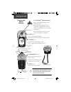
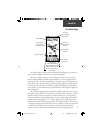
Before you begin to explore the eTrex Vista’s operat-
ing features, you should be familiar with the information
contained in the Quick Start which includes instructions
for installing batteries, how the buttons function, starting
the eTrex Vista, adjusting the screen contrast, and basic
navigation techniques to help you start enjoying your eTrex
Vista immediately.
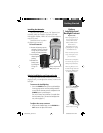
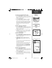
Six Main Pages are your primary access to operating
the eTrex Vista. Each page provides either a basic naviga-
tion function or access to features which enhance naviga-
tion or customize the unit’s operation.
This manual is arranged on the Main Pages structure
with detailed instructions on using the eTrex Vista’s features
and their options.
Features include:
Storage for 500 Waypoints with name and graphic
symbol.
An automatic Track Log with storage capability for
3,000 points, or 10 saved Tracks with 250 points each.
Route building capability, with storage for 20 Routes
with 50 Waypoints each.
A Trip Computer for displaying a variety of navigation
data such as speed, ETA, ETE, heading, odometer, etc.
An Elevation Computer for displaying total ascent/
descent, average ascent/descent, maximum ascent/descent,
12 hour pressure trend, and maximum/minimum eleva-
tion.
A Find Feature for locating Waypoints, Cities,
Interstate Exits, Points of Interest, Street Addresses and
Intersections.*
24 MB of detailed map data storage, allowing transfer
from GARMIN MapSource CD-ROM’s.
Wide Area Augmentation System (WAAS) capability.**
Getting Started
* Points of Interest, Address,
and Intersection data must be
transferred to the unit using a
GARMIN MapSource CD-ROM.
See page 62 for more informa-
tion.
** About WAAS
Because the Wide Area
Augmentation System (WAAS)
is currently under development
and is not fully supported by
geo-stationary satellites, effective
use of the WAAS feature may be
limited by your geographic loca-
tion in relation to those satellites
now in service.
There are two WAAS satellites
in service in geo-stationary orbit
above the Equator, one over the
Atlantic Ocean and one over the
Pacifi c Ocean.
Currently, WAAS satellite signal
reception requires an absolute
clear view of the sky and works
best when there are no nearby
obstructions such as buildings,
mountains, etc. In fact, you may
not be able to receive or easily
maintain a WAAS satellite signal
until full satellite support for this
program is complete.
Not enabling WAAS when you
cannot receive a signal speeds
unit map drawing and conserves
battery power.
See pages 5 and 53 for enabling
WAAS and satellite reception
techniques.
190-00219-00_0C.indd 1 9/20/2002, 9:54:10 AM