


14
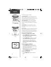
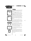
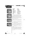
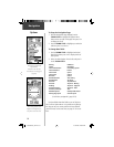
Setup Map Options
Map
Page Setup
Map Features Setup
Text Setup
Tracks Setup
(For defi nitions, see Appendix C, pages 52-53.)
The ‘ Setup Map’ option displays the fi ve Map Setup
Pages, each accessed by an on-screen button. A list of
options displays for the features listed. Scale options
indicate the point at which Tracks, Tracks Logs, Map Fea-
tures, or Text Boxes are visible, allowing you to remove
map clutter and defi ne map features.
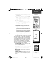
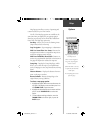
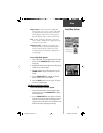
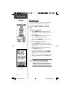
Page - Orientation:
‘Track Up’ or ‘ North Up’;
fixes the top
of the map display to the current track heading or to a north
heading.
Auto Zoom:
On or Off;
automatically scales the
map to display both your current location and the next
point to which you are navigating.
Detail:
Most, More, Normal, Less, or Least;
controls
how much map detail you see. This setting only applies to a
map feature set to ‘Auto’. Those features which have a specified
scale or are turned ‘Off’ are unaffected by this setting.
Lat/Lon Grid:
On or Off;
turns the lattitude and
longitude grid lines on or off.
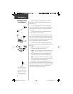
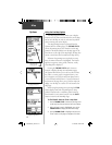
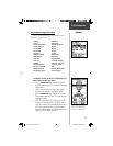
Tracks -
Saved Tracks and Track Log:
Scale options;
‘Off’, ‘Auto’, or 20 ft.-500 miles, sets the maximum scale
at which the feature should appear on the screen. Some
types of data will display only to certain zoom scales.
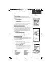
Goto Line:
Bearing or Course;
determines which
pointer displays.
Sunrise
Sunset
Time of Day
To Course
Trip Odometer
Trip Time - Moving
Trip Time - Stopped
Trip Time - Total
Turn
Velocity Made Good
Vertical Speed
(Continued)
Final ETA
Final ETE
Heading
Maximum Speed
Moving Avg. Speed
Odometer
Off Course
Overall Avg. Speed
Pointer
Speed
190-00203-00_0D.indd 14 12/12/2002, 2:58:17 PM