


5
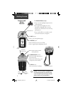
Satellite
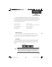
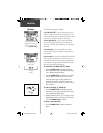
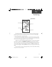
The Main Page
Satellite Page
with 10 Satellites Being
Tracked and WAAS Enabled.
WAAS Satellite is No. 35
and ‘D’ in Signal Bars for
GPS Satellites
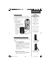
Center (Satellite
overhead)
Status Window
Your location
coordinates and
Elevation
Signal Strength bars
Option and Main
Page Menu Buttons
Outer Ring
(Satellites on the
horizon)
Inner Ring (Satel-
lites within 45°
angle from vertical)
The Satellite Page provides a picture of satellite signal tracking, tells you when the
unit is ready for navigation, and shows your location coordinates.
The Skyview graphic represents a view looking up at the sky from your current
location showing satellites and their assigned numbers. The outer ring represents the
horizon around you, the inner ring represents a view above you at a 45° angle from ver-
tical, and the center represents directly overhead. Signal Strength Bars for each satellite
are shown just below the Skyview. Satellites and their signals appear as hollow shapes
until a signal is received and then they appear darkened in. The stronger the signal, the
taller the signal bar.
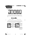
The Wide Area Augmentation System (WAAS) capability produces a more accurate
position fi x. When enabled (the GPS mode set to ‘Normal’ and the interface set to other
than RTCM mode), this feature searches for a WAAS satellite near your location and
then receives data for correcting differentials in the GPS satellite signals and the WAAS
satellite numbers (Number 33 or above) display on the Satellite Page. When differential
correction data has been received for GPS satellites (number 32 or below), a ‘D’ displays
in the signal bar beneath the skyview. It is helpful to orient the unit antenna toward the
WAAS satellite shown in the skyview. To learn more about the WAAS System, access the
Federal Aviation Administration web site (http.//gps.faa.gov/).
190-00203-00_0D.indd 5 12/12/2002, 2:58:12 PM