


Cleaning the Screen
NOTICE
Cleaners containing ammonia will harm the anti-reflective
coating.
The device is coated with a special anti-reflective coating which
is very sensitive to skin oils, waxes, and abrasive cleaners.
1
Apply an eyeglass lens cleaner specified as safe for anti-
reflective coatings to the cloth.
2
Gently wipe the screen with a soft, clean, lint-free cloth.
Screenshots
You can capture a screenshot of any screen shown on your
chartplotter as a bitmap (.bmp) file. You can transfer the
screenshot to your computer.
Capturing Screenshots
1
Insert a memory card into the card slot.
2
Select Settings > System > Display > Screenshot Capture
> On.
3
Go to a screen you want to capture.
4
Hold HOME for at least six seconds.
Copying Screenshots to a Computer
1
Remove the memory card from the chartplotter, and insert it
into a card reader that is attached to a computer.
2
From Windows
®
Explorer, open the Garmin\scrn folder on
the memory card.
3
Copy a .bmp file from the card and paste it to any location on
the computer.
Troubleshooting
Restoring the Original Chartplotter Factory Settings
NOTE: This will delete all settings information you have
entered.
Select Settings > System > System Information > Factory
Settings.
Viewing System Software Information
You can view the software version, the basemap version, any
supplemental map information (if applicable), the software
version for an optional Garmin radar (if applicable), and the unit
ID number. You may need this information to update the system
software or to purchase additional map data information.
Select Settings > System > System Information >
Software Information.
My device will not acquire GPS signals
If the device is not acquiring satellite signals, there could be few
causes. If the device has moved a large distance since the last
time it has acquired satellites or has been turned off for longer
than a few weeks or months, the device may not be able to
acquire the satellites correctly.
• Ensure the device is using the latest software. If not, update
the device software (Updating the Device Software).
• If the device is using an internal GPS antenna, make sure
the device has a clear view of the sky so that the internal
antenna can receive the GPS signal. If it is mounted inside of
a cabin, it should be close to a window so it can receive the
GPS signal. If the device is mounted inside a cabin and
cannot be placed in a location where the device can acquire
satellites, use an external GPS antenna.
• If the device is using an external GPS antenna, make sure
the antenna is connected to the chartplotter or the NMEA
network.
• If the device has more than one GPS antenna source, select
a different source (Selecting the GPS Source).
My device will not turn on or keeps turning off
Devices erratically turning off or not turning on could indicate an
issue with the power supplied to the device. Check these items
to attempt to troubleshoot the cause of the power issue.
• Make sure the power source is generating power.
You can check this several ways. For example, you can
check whether other devices powered by the source are
functioning.
• Check the fuse in the power cable.
The fuse should be located in a holder that is part of the red
wire of the power cable. A 3 Amp fuse is used in this power
cable. Check the fuse to make sure there is still a connection
inside of the fuse. You can test the fuse using a multimeter. If
the fuse is good, the multimeter reads 0 ohms.
• Check to make sure the device is receiving is at least 10
volts, but 12 volts is recommended.
To check the voltage, measure the female sockets 8 (power)
and 2 (ground) of the power cable for DC voltage. If the
voltage is less than 10 volts, the device will not turn on.
• If the device is receiving enough power but does not turn on,
contact Garmin product support at www.garmin.com/support.
My device is not creating waypoints in the correct
location
You can manually enter a waypoint location to transfer and
share data from one device to the next. If you have manually
entered a waypoint using coordinates, and the location of the
point does not appear where the point should be, the map
datum and position format of the device may not match the map
datum and position format originally used to mark the waypoint.
Position format is the way in which the GPS receiver's position
appears on the screen. Commonly displayed as latitude/
longitude in degrees and minutes, with options for degrees,
minutes and second, degrees only, or one of several grid
formats.
Map datum is a math model which depicts a part of the surface
of the earth. Latitude and longitude lines on a paper map are
referenced to a specific map datum.
1
Find out which map datum and position format was used
when the original waypoint was created.
If the original waypoint was taken from a map, there should
be a legend on the map that lists the map datum and position
format used to create that map. Most often this is found near
the map key.
2
On the chartplotter, select Settings > Units.
3
Select the correct map datum and position format settings.
4
Create the waypoint again.
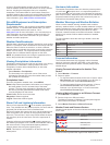
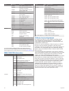
NMEA 0183 Information
Type Sentence Description
Transmit GPAPB APB: Heading or track controller
(autopilot) sentence "B"
GPBOD BOD: Bearing (origin to
destination)
GPBWC BWC: Bearing and distance to
waypoint
GPGGA GGA: Global positioning system
fix data
GPGLL GLL: Geographic position
(latitude and longitude)
GPGSA GSA: GNSS DOP and active
satellites
Appendix 33