


Select Settings > My Vessel.
Keel Offset: Offsets the surface reading for the depth of a keel,
making it possible to measure depth from the bottom of the
keel instead of from the transducer location (Setting the Keel
Offset).
Temp. Offset: Compensates for the water temperature reading
from a NMEA 0183 water-temperature sensor or a
temperature-capable transducer (Setting the Water
Temperature Offset).
Calibrate Water Speed: Calibrates the speed-sensing
transducer or sensor (Calibrating a Water Speed Device).
Fuel Capacity: Sets the combined fuel capacity of all the fuel
tanks on your vessel (Setting the Fuel Capacity of the
Vessel).
Vessel Type: Enables some chartplotter features based on the
boat type.
Fill Up All Tanks: Sets the tank levels to full (Synchronizing the
Fuel Data with the Actual Vessel Fuel).
Add Fuel to Boat: Allows you to enter the quantity of fuel you
added to your tank, when you did not entirely fill up the tank
(Synchronizing the Fuel Data with the Actual Vessel Fuel).
Set Total Fuel Onboard: Sets the combined amount of fuel in
all the fuel tanks on your vessel (Synchronizing the Fuel
Data with the Actual Vessel Fuel).
Set Gauge Limits: Sets the upper and lower limits of various
gauges (Customizing Engine Gauge and Fuel Gauge Limits).
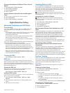
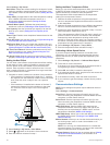
Setting the Keel Offset
You can enter a keel offset to compensate the surface reading
for the depth of a keel, making it possible to measure depth
from the bottom of the keel instead of from the transducer
location. Enter a positive number to offset for a keel. You can
enter a negative number to compensate for a large vessel that
may draw several feet of water.
1
Complete an action, based on the location of the transducer:
• If the transducer is installed at the water line
À
, measure
the distance from the transducer location to the keel of the
boat. Enter this value in steps 3 and 4 as a positive
number.
• If the transducer is installed at the bottom of the keel
Á
,
measure the distance from the transducer to the water
line. Enter this value in steps 3 and 4 as a negative
number.
2
Select Settings > My Vessel > Keel Offset.
3
Select or based on the location of the transducer.
4
Enter the distance measured in step 1.
Setting the Water Temperature Offset
Before you can set the water temperature offset, you must have
a NMEA 0183 water-temperature sensor or a temperature-
capable transducer to measure water temperature.
The temperature offset compensates for the temperature
reading from a temperature sensor.
1
Measure the water temperature using the temperature
sensor or temperature-capable transducer that is connected
to the chartplotter.
2
Measure the water temperature using a different temperature
sensor or a thermometer that is known to be accurate.
3
Subtract the water temperature measured in step 1 from the
water temperature measured in step 2.
This is the temperature offset. Enter this value in step 5 as a
positive number if the sensor connected to the chartplotter
measures the water temperature as being colder than it
actually is. Enter this value in step 5 as a negative number if
the sensor connected to the chartplotter measures the water
temperature as being warmer than it actually is.
4
Select Settings > My Vessel > Temp. Offset.
5
Enter the temperature offset calculated in step 3.
Calibrating a Water Speed Device
If you have a speed-sensing transducer connected to the
chartplotter, you can calibrate that speed-sensing device to
improve the accuracy of water-speed data displayed by the
chartplotter.
1
Select Settings > My Vessel > Calibrate Water Speed.
2
Follow the on-screen instructions.
If the boat is not moving fast enough or the speed sensor is
not registering a speed, a message appears.
3
Select OK, and safely increase the boat speed.
4
If the message appears again, stop the boat, and ensure the
speed-sensor wheel is not stuck.
5
If the wheel turns freely, check the cable connections.
6
If you continue to get the message, contact Garmin product
support.
Communications Settings
NOTE: Some settings and options require additional charts or
hardware.
Select Settings > Communications.
Serial Port 1: Sets the input/output format for port 1 to use
when connecting the chartplotter to external NMEA devices,
computers, or other Garmin devices.
Serial Port 2: Sets the input/output format for port 2 to use
when connecting the chartplotter to external NMEA devices,
computers, or other Garmin devices.
NMEA 0183 Setup: Sets the NMEA 0183 sentences the
chartplotter transmits, how many digits to the right of the
decimal point are transmitted in a NMEA output, and how
waypoints are identified (NMEA 0183 Settings).
NMEA 2000 Setup: Allows you to view and label the devices on
the NMEA 2000 network (Viewing a List of NMEA 2000
Network Devices).
Marine Network: Allows you to view the devices with which you
are sharing maps, sonar, or radar. Not available on all
chartplotter models.
NOTE: You can only view networked data on a model that
supports that data. For example, you cannot view networked
radar on model that does not support radar.
Wireless Devices: Allows you set up wireless devices (Setting
Up the Wi‑Fi
®
Wireless Network). Not available on all
chartplotter models.
30 Device Configuration