


7
Select Navigate Route.
8
Review the course indicated by the magenta line.
9
Follow the magenta line, steering to avoid land, shallow
water, and other obstacles.
Creating and Saving a Route
This procedure saves the route and all the waypoints in it. The
starting point can be your present location or another location.
1
Select Nav Info > Routes > New Route > Use Chart.
2
Select the starting location of the route.
3
Select Add Turn.
4
Select the location of the next turn on the chart.
5
Select Add Turn.
The chartplotter marks the location of the turn with a
waypoint.
6
If necessary, repeat steps 4 and 5 to add more turns.
7
Select the final destination.
Viewing a List of Routes
Select Nav Info > Routes.
Editing a Saved Route
You can change the name of a route or change the turns the
route contains.
1
Select Nav Info > Routes.
2
Select a route.
3
Select Edit Route.
4
Select an option:
• To change the name, select Name, and enter the name.
• To select a waypoint from the turn list, select Edit Turns
> Use Turn List, and select a waypoint from the list.
• To select a turn using the chart, select Edit Turns > Use
Chart, and select a location on the chart.
Browsing for and Navigating a Saved Route
Before you can browse a list of routes and navigate to one of
them, you must create and save at least one route.
1
Select Nav Info > Routes.
2
Select a route.
3
Select Navigate To.
4
Select an option:
• To navigate the route from the starting point used when
the route was created, select Forward.
• To navigate the route from the destination point used
when the route was created, select Backward.
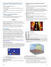
A magenta line appears. In the center of the magenta line is
a thinner purple line that represents the corrected course
from your present location to the destination. The corrected
course is dynamic, and it moves with your boat when you are
off course.
5
Review the course indicated by the magenta line.
6
Follow the magenta line along each leg in the route, steering
to avoid land, shallow water, and other obstacles.
7
If you are off course, follow the purple line (corrected course)
to go to your destination, or steer back to the magenta line
(direct course).
Browsing for and Navigating Parallel to a Saved
Route
Before you can browse a list of routes and navigate to one of
them, you must create and save at least one route.
1
Select Nav Info > Routes.
2
Select a route.
3
Select Navigate To.
4
Select Offset to navigate parallel to the route, offset from it
by a specific distance.
5
Indicate how to navigate the route:
• To navigate the route from the starting point used when
the route was created, to the left of the original route,
select Forward – Port.
• To navigate the route from the starting point used when
the route was created, to the right of the original route,
select Forward – Starboard.
• To navigate the route from the destination point used
when the route was created, to the left of the original
route, select Backward – Port.
• To navigate the route from the destination point used
when the route was created, to the right of the original
route, select Backward – Starboard.
6
If necessary, select Done.
A magenta line appears. In the center of the magenta line is
a thinner purple line that represents the corrected course
from your present location to the destination. The corrected
course is dynamic, and it moves with your boat when you are
off course.
7
Review the course indicated by the magenta line.
8
Follow the magenta line along each leg in the route, steering
to avoid land, shallow water, and other obstacles.
9
If you are off course, follow the purple line (corrected course)
to go to your destination, or steer back to the magenta line
(direct course).
Deleting a Saved Route
1
Select Nav Info > Routes.
2
Select a route.
3
Select Delete.
Deleting All Saved Routes
Select Nav Info > Manage Data > Clear User Data >
Routes.
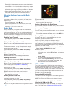
Tracks
A track is a recording of the path of your boat. The track
currently being recorded is called the active track, and it can be
saved. You can show tracks in each chart or 3D chart view.
Showing Tracks
From a chart or a 3D chart view, select MENU > Waypoints
& Tracks > Tracks > On.
A trailing line on the chart indicates your track.
Setting the Color of the Active Track
1
Select Nav Info > Tracks > Active Track Options > Track
Color.
2
Select a track color.
Saving the Active Track
The track currently being recorded is called the active track.
1
Select Nav Info > Tracks > Save Active Track.
2
Select an option:
• Select the time the active track began.
• Select Entire Log.
3
Select Save.
Viewing a List of Saved Tracks
Select Nav Info > Tracks > Saved Tracks.
Editing a Saved Track
1
Select Nav Info > Tracks > Saved Tracks.
Navigation with a Chartplotter 11