Style: Sets how the chart appears over 3D terrain.
Hazard Colors: Shows shallow water and land with a color
scale. Blue indicates deep water, yellow is shallow water,
and red is very shallow water.
Safe Depth: Sets the appearance of a safe depth for Mariner’s
Eye 3D.
NOTE: This setting affects only the appearance of hazard
colors in Mariner’s Eye 3D. It does not affect the safe water
depth Auto Guidance setting or the sonar shallow water
alarm setting.
Range Rings: Shows and configures the appearance of range
rings, which help you to visualize distances in some chart
views.
Lane Width: Specifies the width of the navigation lane, which is
the magenta line in some chart views that indicates the
course to your destination.
Setting the Heading and Course Over Ground Lines
You can show the heading line and the course over ground
(COG) line on the chart.
COG is your direction of movement. Heading is the direction the
bow of the boat is pointed, when a heading sensor is
connected.
1
From a chart view, select MENU > Chart Setup > Chart
Appearance > Heading Line.
2
If necessary, select Source, and select an option:
• To automatically use the source available, select Auto.
• To use the GPS antenna heading for COG, select GPS
Heading (COG).
• To use data from a connected heading sensor, select
North Reference.
• To use data from both a connected heading sensor and
the GPS antenna, select COG and Heading.
This displays both the heading line and the COG line on
the chart.
3
Select Display, and select an option:
• Select Distance > Distance, and enter the length of the
line shown on the chart.
• Select Time > Time, and enter the time used to calculate
the distance your boat will travel in the specified time at
your present speed.
Other Vessels Settings on the Charts and Chart
Views
NOTE: These options require connected accessories, such as
an AIS receiver or VHF radio.
From a chart or 3D chart view, select MENU > Other Vessels.
AIS/MARPA List: Shows the AIS list (Viewing a List of AIS
Threats).
DSC List: Shows the DSC list (DSC List).
AIS/MARPA Dis. Setup: See AIS Display Settings.
DSC Trails: Shows the tracks of DSC vessels, and selects the
length of the track that appears using a trail.
AIS/MARPA Alarm: Sets the safe-zone collision alarm (Setting
the Safe-Zone Collision Alarm).
AIS Display Settings
NOTE: AIS requires the use of an external AIS device and
active transponder signals from other vessels.
From a chart or 3D chart view, select MENU > Other Vessels >
AIS/MARPA Dis. Setup.
AIS Dis. Range: Indicates the distance from your location within
which AIS vessels appear.
Details: Shows details about AIS-activated vessels.
Proj. Heading: Sets the projected heading time for AIS-
activated vessels.
Trails: Shows the tracks of AIS vessels, and select the length of
the track that appears using a trail.
Fish Eye 3D Settings
NOTE: This feature is available with premium charts, in some
areas.
From the Fish Eye 3D chart view, select MENU.
View: Sets the perspective of the 3D chart view.
Tracks: Shows tracks.
Sonar Cone: Shows a cone that indicates the area covered by
the transducer.
Fish Symbols: Shows suspended targets.
Navigation with a Chartplotter
CAUTION
If your vessel has an autopilot system, a dedicated autopilot
control display must be installed at each steering helm in order
to disable the autopilot system.
The Auto Guidance feature is based on electronic chart
information. That data does not ensure obstacle and bottom
clearance. Carefully compare the course to all visual sightings,
and avoid any land, shallow water, or other obstacles that may
be in your path.
NOTE: Auto Guidance is available with premium charts, in
some areas.
NOTE: Mariner's Eye 3D and Fish Eye 3D chart views are
available with premium charts, in some areas.
NOTE: The offshore Fishing chart is available with premium
charts, in some areas.
To navigate, you must choose a destination, set a course or
create a route, and follow the course or route. You can follow
the course or the route on the Navigation chart, Fishing chart,
Perspective 3D chart view, or Mariner’s Eye 3D chart view.
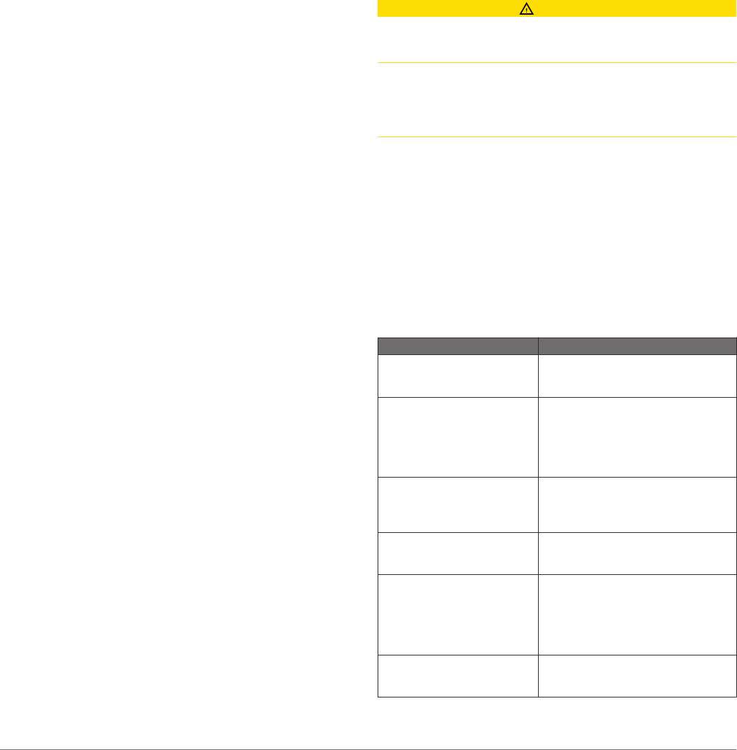
Basic Navigation Questions
Question Answer
How do I make the chartplotter
point me in the direction in
which I want to go (bearing)?
Navigate using Go To. See Setting
and Following a Direct Course Using
Go To.
How do I make the device
guide me along a straight line
(minimizing cross track) to a
location using the shortest
distance from the present
location?
Build a single-leg route and navigate it
using Route To. See Creating and
Navigating a Route From Your
Present Location.
How do I make the device
guide me to a location while
avoiding charted obstacles?
Build a multi-leg route and navigate it
using Route To. See Creating and
Navigating a Route From Your
Present Location.
How do I make the device
steer my automatic pilot?
Navigate using Route To. See
Creating and Navigating a Route From
Your Present Location.
Can the device create a path
for me?
If you have premium maps that
support Auto Guidance and are in an
area covered by Auto Guidance,
navigate using Auto Guidance. See
Setting and Following a Course Using
Auto Guidance.
How do I change the Auto
Guidance settings for my
boat?
See Auto Guidance Line
Configurations.
8 Navigation with a Chartplotter


