


Destinator 6 34
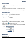
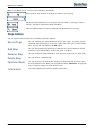
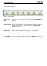
Settings
GPS Settings
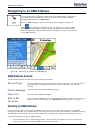
Destinator uses the GPS receiver to pinpoint your location. GPS signals are
automatically acquired and your vehicle's location and position are constantly
updated unless you are working in the Free Browse Map mode or you tap the
GPS Off button. The GPS receiver may take a few minutes to find its initial
location. For best results, ensure that the GPS receiver has a clear view of
the sky.
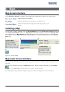
The following GPS information is displayed:
Longitude - The angular distance east or west on the earth's surface.
Latitude - The location of a place north or south of the earth's surface.
Speed - The rate of movement, as expressed by kilometers or miles per hour.
Altitude - The height above sea level.
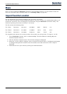
The GPS On and GPS Off buttons let you connect or disconnect from the GPS
receiver. If you are working in Free Browse Map mode, Destinator automatically disconnects from the GPS
receiver.
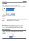
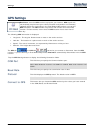
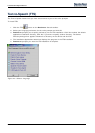
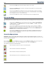
Tap the GPS Settings button to display the following Connection fields:
COM Port
This field lets you specify the Communications port.
Note: Most Bluetooth receivers use COM 6 or COM 8. Most serial receivers use
COM 1.
Baud Rate
This field lets you specify the transmission rate of data.
Protocol
This field displays the GPS protocol. The default value is NMEA.
Note: Most receivers use NMEA 4800.
Connect to GPS
This button lets you locate the GPS receiver by the values you have entered
in the COM, Baud, and Protocol fields.