38
Navman SmartS™ Professional for Palm OS
®
5
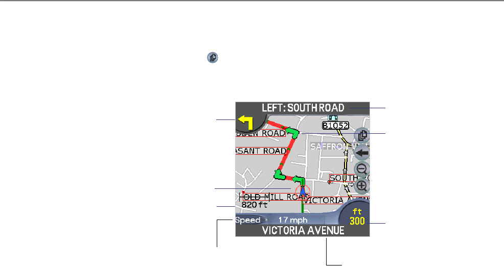
10-2 Navigation View
The Navigation view is displayed when you calculate a route, except that the map is always oriented in the direction in
which your vehicle is travelling. This is often an easier way to keep your bearings.
1 To view the route, tap on the
symbol to cycle through the screens until the Navigation Screen is displayed.
2 Zoom in and out as required.
Tap this button to cycle through the following
data display options:
• Current speed (displayed)
• Current time
• Current bearing / heading (HDG)
• Distance to go to destination (DTG)
• Expected time of arrival at destination (ETA)
• Time to go to destination (TTG)
Map scale
Direction of next
turn. Tap this icon to
announce the current
instruction
The street you
are travelling on
Your current position is
marked with this icon,
blue indicates a valid
GPS fi x, red no GPS fi x
Turns are highlighted
in green
Next instruction and
Road Name
Distance to next turn
Note: to view this
screen, a route must
be calculated.
The map automatically
zooms in or out depending
on the speed of travel.
The map may be zoomed
manually but will snap back
to the auto zoom level after a
short delay.


