


65
MN002000A © 2004 Navman NZ Ltd. All rights reserved. Proprietary information and specifications subject to change without notice.
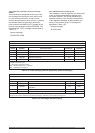
4.6.2 Platform class
The Jupiter GPS receiver supports three platform
classes:
pedestrian (low dynamics
automotive (medium dynamics)
aircraft (high dynamics)
The platform class is set by the OEM to optimise
navigation processing for the dynamics of the
specific platform that is carrying the receiver. The
class is used to set process noise parameters,
velocity decay time constants, and speed and
altitude limits.
The default platform class is automotive. The
OEM sets the platform class using the Application
Platform Control message (binary Message 1220).
The platform class is stored in EEPROM, so it is
retained when power is turned off.
4.6.2.1 Pedestrian
This platform class is used when the receiver is
mobile in a low dynamic environment. An example
would be a hand-held GPS receiver used for
hiking.
4.6.2.2 Automotive
This platform class is for moderate dynamic
environments where altitude is not constant.
A common example would be a car, truck, or
motorcycle.
4.6.2.3 Aircraft.
This platform class is for high dynamic
environments where altitude may change rapidly.
4.6.3 Navigation cycle
The navigation software nominally executes once
per second. During each execution, the navigation
state is propagated forward to the current time and
updated with any available measurements. The
navigation solution is then provided to the serial
interface for output in the selected message set
(either Navman binary or NMEA).
Note: NMEA may be slightly delayed compared to
the binary data.
4.6.3.1 State propagation
User state propagation over the measurement
update interval, nominally one second, is by dead
reckoning with constant tangent plane velocity. The
tangent plane is defined by the current position
and the selected datum. This means that if the
vertical velocity is zero, the state propagation will
be at constant altitude in the user-selected datum.
For Pedestrian, Automotive, and Aircraft platforms,
user state propagation is in three dimensions.
Once the receiver has been navigating and a
velocity has been established by the Kalman filter,
it will be used to propagate the state forward in the
absence of further measurements for a limited time
period, until the estimated errors in the propagated
velocity have reached certain limits. Once these
limits are reached, Pedestrian (low dynamics).
Automotive (medium dynamics). Aircraft (high
dynamics), the velocity estimate is considered less
reliable and is decayed exponentially with platform
class dependent time constants.
4.6.3.2 Measurement processing
Once four satellites are available above the
elevation mask angle with ephemeris data and
sufficiently good geometry, the Kalman filter begins
to process the measurements. The Kalman filter
processes two measurements for each satellite,
the integrated carrier phase measurement (also
known as carrier-smoothed pseudo-range) and the
Doppler, or range rate, measurement.
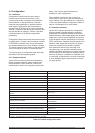
4.6.3.3 Altitude processing
The receiver uses altitude aiding if a source is
available and the Expected Vertical Position
Error (EVPE) exceeds a threshold. The sources
available for aiding, in the order of preference for
use, are:
1 user-entered altitude.
2 held altitude. ROM altitude (acquisition only).
3 ROM altitude (acquisition only)
User-entered altitude
The ‘user-entered altitude input’ message (binary
Message 1219) is used to supply an altitude to
the receiver. The altitude can be specified as
instantaneous, valid until cleared from RAM, or
valid until cleared from EEPROM. Instantaneous
altitude is valid for one navigation cycle only.
This altitude input type is used when there is a
continuous source of external altitude data.
Held altitude
Held altitude is stored in the receiver when the
navigation solution is valid. The held altitude is
stored with a variance that grows from the last
time it was updated to reflect the age and growing
uncertainty of the altitude estimate.
Use of held altitude is normally a significant
performance boost in an urban environment with
heavy blockage and it is enabled by default. A
held altitude value is discarded if the estimated
climb rate magnitude exceeds 1 m/s. The OEM
can disable the use of held altitude using the ‘nav
configuration’ message (binary Message 1221).
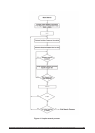
4.6.3.4 Position pinning
When the receiver is not using DGPS, satellite
measurements include time varying range errors.