


120
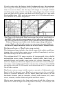
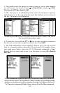
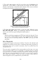
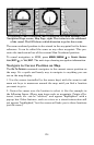
6. The unit's map appears, with the cross-hair cursor highlighting the
restaurant' s POI symbol. A pop-up data box shows the POI's name,
distance and bearing. A data box at the bottom of the screen continues
to display the location's latitude and longitude.
Map screen showing Finding Waypoint,
the result of a restaurant search.
7. To clear the search and return to the last page displayed, press
EXIT|EXIT|EXIT|EXIT. (Before you completely exited out of the Search
menus, you could have gone looking for another place.)
NOTE:
Search works from mapping and POI data loaded in the unit. If you
do not have a high-detailed custom map (containing POI data) for
the area you are searching loaded on the MMC, you may not find
anything.
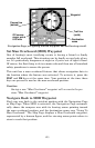
Set a Waypoint
A waypoint is simply an electronic "address," based on the latitude and
longitude of a position on the earth. A waypoint represents a location or
destination that can be stored in memory, then be recalled later for
navigational use.
You can create a waypoint at the cursor position on the map, or at your
current position while you are navigating. A waypoint may be created
at any location by manually entering the position's latitude and longi-
tude. You can copy waypoints from your unit to your personal computer
with MapCreate software. When you want to repeat a trip, these ar-
chived waypoints can be reloaded into your GPS unit.